Moyon
| Moyon | |
|---|---|
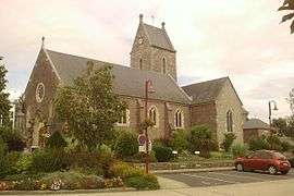 The church of Saint-Germain | |
 Moyon Location within Normandy region  Moyon | |
| Coordinates: 49°00′05″N 1°07′02″W / 49.0014°N 1.1172°WCoordinates: 49°00′05″N 1°07′02″W / 49.0014°N 1.1172°W | |
| Country | France |
| Region | Normandy |
| Department | Manche |
| Arrondissement | Saint-Lô |
| Canton | Condé-sur-Vire |
| Government | |
| • Mayor (2008–2014) | Gilles Beaufils |
| Area1 | 23.74 km2 (9.17 sq mi) |
| Population (2006)2 | 1,056 |
| • Density | 44/km2 (120/sq mi) |
| Demonym(s) | Moyonnais |
| Time zone | UTC+1 (CET) |
| • Summer (DST) | UTC+2 (CEST) |
| INSEE/Postal code | 50363 /50860 |
| Elevation |
50–145 m (164–476 ft) (avg. 87 m or 285 ft) |
| Website | membres.lycos.fr/communemoyon |
|
1 French Land Register data, which excludes lakes, ponds, glaciers > 1 km2 (0.386 sq mi or 247 acres) and river estuaries. 2 Population without double counting: residents of multiple communes (e.g., students and military personnel) only counted once. | |
Moyon is a former commune in the Manche department in Normandy in north-western France. On 1 January 2016, it was merged into the new commune of Moyon-Villages.[1]
See also
References
- ↑ Arrêté préfectoral 28 September 2015 (in French)
| Wikimedia Commons has media related to Moyon. |
This article is issued from
Wikipedia.
The text is licensed under Creative Commons - Attribution - Sharealike.
Additional terms may apply for the media files.