Mount Wellington, New Zealand
| Mount Wellington | |
|---|---|
 | |
| Basic information | |
| Local authority | Auckland Council |
| Local board | Maungakiekie-Tamaki |
| Facilities | |
| Train station(s) | Sylvia Park Railway Station |
| Surrounds | |
| North | Ellerslie, St. John's Park, Panmure |
| East | Tamaki River, Pakuranga, Panmure |
| Southeast | Panmure |
| South | Westfield |
| West | Penrose |
Mount Wellington is a suburb in East Auckland, New Zealand, located 10 kilometres southeast of the city centre. It is surrounded by the suburbs of Stonefields, Tamaki, Panmure, Penrose, and Ellerslie, and by the Tamaki River. The suburb is named after the volcanic peak of Maungarei / Mount Wellington. Sylvia Park is a large business park and shopping centre located in the suburb.
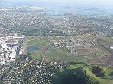
Stonefields subdivision and Mount Wellington
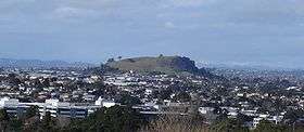
Maungarei
Maungarei / Mount Wellington is a 135-metre[1] volcanic peak of the Auckland volcanic field. It is the youngest onshore volcano of the Auckland volcanic field, having been formed by an eruption around 10,000 years ago. It is the largest of Auckland's scoria cones.[2] It is not expected to erupt again.
Education
- Bailey Road School is a state, coeducational full primary (years 1-8) school with a roll of 418 and a decile rating of 3.[3]
- Stanhope Road School is a state, coeducational full primary (years 1-8) school with a roll of 495 and a decile rating of 4. It was established in 1958.[4]
- Sylvia Park School is a state, coeducational full primary (years 1-8) school with a roll of 248 and a decile rating of 2.[5]
- Stonefields School is a school right at the base of Mt Wellington. It is a full primary (years 1-8) school
References
- ↑ "Archived copy". Archived from the original on 11 February 2009. Retrieved 5 March 2009.
- ↑ "Volcanoes of Auckland: Mt Wellington". Auckland Regional Council. Archived from the original on 11 February 2009. Retrieved 5 March 2009.
- ↑ Te Kete Ipurangi schools database: Bailey Road School
- ↑ Te Kete Ipurangi schools database: Stanhope Road School
- ↑ Te Kete Ipurangi schools database: Sylvia Park School
- Volcanoes of Auckland: The Essential guide - Hayward, B.W., Murdoch, G., Maitland, G.; Auckland University Press, 2011.
External links
Coordinates: 36°53′31″S 174°50′48″E / 36.891909°S 174.846554°E
- Bailey Road School
- Stanhope school
- Sylvia Park School
- Photographs of Mount Wellington held in Auckland Libraries' heritage collections.
This article is issued from
Wikipedia.
The text is licensed under Creative Commons - Attribution - Sharealike.
Additional terms may apply for the media files.