Mount Weather Emergency Operations Center
| Mount Weather | |
|---|---|
|
State Route 601, Loudoun–Clarke counties, near Bluemont, Virginia | |
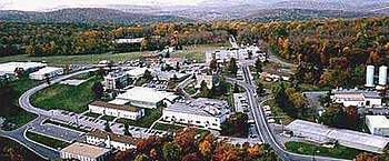 Mount Weather, with the Shenandoah Valley in the background | |
| Type | FEMA command center, permanent Executive Branch substitute |
| Site information | |
| Controlled by | U.S. Department of Homeland Security |
| Status | In Service |
| Site history | |
| Built | Unknown |
| In use | 1959–present |
The Mount Weather Emergency Operations Center is a civilian command facility in the U.S. Commonwealth of Virginia, used as the center of operations for the Federal Emergency Management Agency (FEMA). Also known as the High Point Special Facility (HPSF), its preferred designation since 1991 is "SF".[1]
The facility is a major relocation site for the highest level of civilian and military officials in case of national disaster, playing a major role in continuity of government (per the U.S. Continuity of Operations Plan).[2]
Mount Weather is the location of a control station for the FEMA National Radio System (FNARS), a high frequency radio system connecting most federal public safety agencies and the U.S. military with most of the states.[3] FNARS allows the president to access the Emergency Alert System.[4]
The site was brought into the public eye by The Washington Post, when the government facility was mentioned while reporting on the December 1, 1974, crash into Mount Weather of TWA Flight 514, a Boeing 727 jetliner.[5]
Location
Located in the Blue Ridge Mountains,[2] access to the operations center is available via State Route 601 (also called Blueridge Mountain Road) in Bluemont, Virginia.[6] The facility is located near Berryville, 48 miles (77 km) west of Washington, D.C.[7]
The site was originally opened as a weather station in the late 1800s.[8] It was used as a Civilian Public Service facility (Camp #114) during World War II.[9][10] At that time there were just two permanent buildings on the site: the administration/dormitory building, and the laboratory. Those buildings still stand, supplemented by many more modern buildings.
The underground facility within Mount Weather, designated "Area B", was completed in 1959. FEMA established training facilities on the mountain's surface ("Area A") in 1979.[11]
The above-ground portion of the FEMA complex (Area A) is at least 434 acres (176 ha). This measurement includes a training area of unspecified size.[11] Area B, the underground component, contains 600,000 square feet (56,000 m2).[7]
Evacuations
According to a letter to the editor of The Washington Post, after the September 11 attacks, most of the congressional leadership was evacuated to Mount Weather by helicopter.[7][12][13]
Between 1979 and 1981, the National Gallery of Art developed a program to transport valuable paintings in its collection to Mount Weather via helicopter. The success of the relocation would depend upon how far in advance warning of an attack was received.[14]
In the media
The first video of Mount Weather shot from the air to be broadcast on national TV was filmed by ABC News producer Bill Lichtenstein, and was included in the 1983 20/20 segment "Nuclear Preparation: Can We Survive", featuring 20/20 correspondent Tom Jarriel. Lichtenstein flew over the Mt. Weather facility with an ABC camera crew. The news magazine report also included House Majority Leader Tip O'Neill and Representative Ed Markey, confirming that there were contingency plans for the relocation of the United States government in the event of a nuclear war or major disaster.
Both Mount Weather and the now deactivated The Greenbrier were featured in the A&E documentary Bunkers. The documentary, first broadcast on October 23, 2001, features extensive interviews with engineers and political and intelligence analysts, providing rare insights into the secret installations. The documentary compared The Greenbrier and Mount Weather to Saddam Hussein's control bunker buried beneath Baghdad. The documentary features interior video of The Greenbrier as well as the Baghdad bunker, which survived direct hits from seven Joint Direct Attack Munition bombs during the Battle of Baghdad in 2003.
Author William Poundstone investigated Mount Weather in his 1989 book Bigger Secrets.
In popular culture
The novel Seven Days in May mentions a facility called Mount Thunder, a reference to Mount Weather, but the road descriptions in the book make it quite clear that it is the same facility.[15] It is also referred to in the movie based on the book, filmed during the Kennedy Administration and released in 1964.
Mount Weather has been the setting for several apocalyptic and post-apocalyptic fictional works. These include the 2002 series finale of The X-Files, the 2008 remake of The Day the Earth Stood Still, the novel series The 100, CW’s TV series The 100 and Syfy’s TV series Z Nation. Mount Weather is also mentioned in the novels One Year After and The Final Day, both by William R. Forstchen.
See also
Notes
- ↑ Gup, Ted (June 24, 2001). "Civil Defense Doomsday Hideaway". Time. Berryville, Virginia. Retrieved November 26, 2017.
- 1 2 "Fire Departments" (PDF). The Lay of the land: the Center for Land Use Interpretation Newsletter. Culver City, CA: The Center for Land Use Interpretation: 6–7. Spring 2002. Archived from the original (PDF) on June 25, 2008. Retrieved April 3, 2008.
- ↑ "Opportunities With OES ACS Program". OES Auxiliary Communications Service Homepage. Governor's (California, USA) Office of Emergency Services. Archived from the original on May 9, 2008. Retrieved April 2, 2008.
- ↑ Merlin, Ross Z. (2004). "Communications Systems for Public Health Contingencies" (PDF). DHS/FEMA Wireless Program Management Team. Archived from the original (PDF) on June 25, 2008. Retrieved April 2, 2008.
- ↑ "Mount Weather; High Point Special Facility (SF), Western Virginia Office". GlobalSecurity.org.
- ↑ Bedard, Paul (December 4, 2005). "Things That Go Bump In The Night At Cheney's Cave". White House Weekly. p. 1.
- 1 2 3 Schwartz, Stephen I. (August 9, 2006). "Near Washington, Preparing for the Worst". The Washington Post. p. A16.
- ↑ "Mt. Weather".
- ↑ "CPS Camp # 114".
- ↑ "CPS Unit Number 114-01".
- 1 2 McGrath, Gareth (January 30, 2002). "Training Site Bunker Used After Sept. 11 Terror Attacks". Morning Star. Wilmington, NC. pp. 1B, 6B.
- ↑ "Mount Weather". Weapons of Mass Destruction (WMD). GlobalSecurity.org. April 27, 2005. Retrieved November 27, 2009.
- ↑ Jeanne Meserve and Mallory Simon (November 26, 2009). "Web site posts what it says are half million text messages from 9/11". CNN. Turner Broadcasting System, Inc. Retrieved November 27, 2009.
- ↑ Gup, Ted (October 10, 1992). "Grab That Leonardo!". Time. Retrieved April 3, 2008.
- ↑ Vanderbilt, Tom (August 28, 2006). "Is This Bush's Secret Bunker?". Comments and Features. The Guardian. London. p. 12. Retrieved April 2, 2008.
References
- Emerson, Steven (August 7, 1989). "America's Doomsday Project". U.S. News & World Report: 26–31.
- Garrett M. Graff (2017). Raven Rock: The Story of the U.S. Government’s Secret Plan to Save Itself. Simon & Schuster.
- ——— (August 10, 1992). "The Doomsday Blueprints". Time: 32–39.
External links
- 1962 Mount Weather Operating Documents
- FEMA page on its Mt. Weather operations as saved by the Internet Archive Wayback Machine on March 30, 2005
- 1956 FBI memo concerning a "Plan C" emergency readiness exercise involving the High Point Communications Center
Coordinates: 39°03′47″N 77°53′20″W / 39.063°N 77.889°W
| |
|