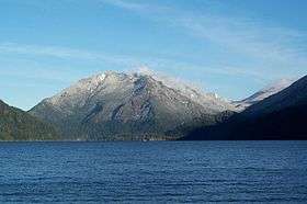
Mount Storm King
| Mount Storm King | |
|---|---|
 | |
| Highest point | |
| Elevation | 4,500+ ft (1,370+ m) NGVD 29[1] |
| Prominence | 750 ft (230 m) [1] |
| Coordinates | 48°03′21″N 123°44′27″W / 48.055708811°N 123.740815125°WCoordinates: 48°03′21″N 123°44′27″W / 48.055708811°N 123.740815125°W [2] |
| Geography | |
 Mount Storm King | |
| Parent range | Olympic Mountains |
| Topo map | USGS Lake Sutherland |
| Climbing | |
| Easiest route | Mount Storm King trail, class 3 |
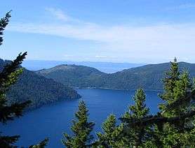
Mount Storm King is located within the Olympic National Park about 20 miles west of Port Angeles, Washington. The mountain is located on the south side of Lake Crescent near Barnes Point, and has an elevation of 4,500+ feet (1,370+ m).
The trail to the summit starts near the Storm King Ranger Station, and initially follows the trail to Marymere Falls but branches to the north after a short distance. The first 1.9 miles (3.1 km) is on maintained trail but the rest of the climb involves scrambling on loose rock with some exposure.[3]
Legend
Klallum tribe legend tells an origin story of Mount Storm King being angered by fighting tribes at his feet and broke a boulder from his peak, throwing it at the warriors, killing them and cutting Tsulh-mut in two creating Lake Crescent and Lake Sutherland.[4][5]
References
- 1 2 "Mount Storm King, Washington". Peakbagger.com.
- ↑ "CON". NGS data sheet. U.S. National Geodetic Survey.
- ↑ Molvar, Erik (2008). Hiking Olympic National Park (2nd ed.). Helena, Mont: Falcon. ISBN 0-7627-4119-8.
- ↑ "Our deep lakes incite curiosity and conjure legends". The Seattle Times. 2014-08-08. Retrieved 2017-01-21.
- ↑ Bragg, Lynn (2015). Washington Myths and Legends: The True Stories behind History’s Mysteries. Rowman & Littlefield. p. 59. ISBN 1493016032.
External links