Seoraksan
| Seoraksan | |
|---|---|
 | |
| Highest point | |
| Elevation | 1,708 m (5,604 ft) |
| Coordinates | 38°7′10″N 128°27′56″E / 38.11944°N 128.46556°ECoordinates: 38°7′10″N 128°27′56″E / 38.11944°N 128.46556°E |
| Geography | |
 Seoraksan Seoraksan is located in the Gangwon Province in eastern South Korea | |
| Location | South Korea |
| Parent range | Taebaek Mountains |
| Climbing | |
| Easiest route | Hike, scramble |
| Korean name | |
| Hangul | 설악산 |
|---|---|
| Hanja | 雪嶽山 |
| Revised Romanization | Seoraksan |
| McCune–Reischauer | Sŏraksan |
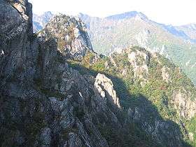
Seoraksan is the highest mountain in the Taebaek mountain range in the Gangwon Province in eastern South Korea.[1] It is located in a national park near the city of Sokcho. After the Hallasan volcano on Jeju Island and Jirisan in the south, Seoraksan is the third highest mountain in South Korea. The Daechongbong Peak (대청봉) of Seoraksan reaches 1,708 meters (5,603 feet). The Taebaek mountain chain is often considered the backbone of the Korean peninsula.[2]

The national park attracts many domestic and international tourists all year round, but the main season for Seoraksan national park is autumn. The autumn colours in the area are considered amongst the most beautiful in Korea. The red and yellow forest is interrupted by rocks and small mountain streams flow amidst this. During the rainy season in summer—especially after a typhoon—these streams can swell.
Perhaps the most visited part of the mountain is the main entrance valley to the National Park, a fifteen-minute drive from Sokcho city. The valley runs west to east with a paved road leading up to the park's entrance gate. This valley contains many beautiful sites and is well worth a day visit.
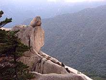
The Yukdam waterfall and the Biryeong waterfall (비룡폭포) are located on the left side of the valley, about a forty-minute walk from the main car park. Ulsanbawi (울산바위) is a rock formation in the Seoraksan national park. [3]The shape of Ulsanbawi is unique in the area. To reach the rocks you need to follow a hiking path and climb over 800 steps (it is actually 888 steps according to locals). On the way there, there are two temples and a spherical rock (Heundeulbawi, 흔들바위) which is located on top of a larger rock.[4] This rock is about 5 meters (16 feet) high and can be moved with some effort. Thousands of people have already tried to push down Heundeulbawi, but nobody gets further than waggling the rock.
Land-based parks are in red and marine parks are in blue.
According to the legend Ulsanbawi comes from the city of Ulsan in the south east of Korea. As Kumgangsan (금강산) was built, Ulsanbawi walked to the north as the representative of the city. Unfortunately Ulsanbawi arrived too late and there was no more room. Ulsanbawi was ashamed and slowly trudged back to the south. One evening the rock went to sleep in the Seorak area. Ulsanbawi felt it was so beautiful around there that it decided to stay for good.
At the end of the main valley is Biseondae, a rock platform in a stream. Above the stream is a difficult to reach cave, which offers clear views of the surrounding rock formations.
A bit farther from the entrance is the Valley of a Thousand Buddhas (천불동계곡), the primary valley of Seorak Mountain, also sometimes referred to as Seorak Valley. The valley was so named because the rock formations that line its sides resemble a line-up of Buddha statues.
The difficulty levels of the different hiking trails are different.
Mountain geography, fauna and flora
It was designated National Natural Park No. 171 in 1965 , and Seoraksan National Park on March 24, 1970.[5] In August 1982, UNESCO designated it as a biosphere reserve.
Mt. Seorak is largely divided into the areas of 'Inner seorak', 'Outer seorak', and the 'Southern seorak'.
It is famous for its splendid valleys and mountains with excellent valleys such as 'Suryem dong valley', 'Baekdam valley, 'Gajadong velly', 'Gugokdam velly', '12 Seonyeo Tang', 'Dae Seung Waterfall' and 'Yonga Jangseong.' In addition to Cholbudong Valley, Ulsan Rock, Cliffs and waterfalls such as Bryong Falls and Toeongseong Falls are beautiful and accessible, making them frequent visitors. In recent years, there are a lot of people in Seolak, which is easy to climb Daecheong-bong, and southern Seorak, which is in the middle of the valley.
The biosphere of the Mt. Seolak is composed of different ecosystems according to climate and characteristics. It is an inland climate with gentle slopes and thick soil layers that are rich in forests and rich in animal habitats, while oyster shells have a marine climate with steep slopes and few visitors. It is home to rare animals and plants, including natural monuments such as goats and bears.
Gallery
 Seoraksan National Park Entrance
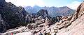 Mount Gwonggeumseong in Seoraksan National Park
 Bronze Buddha of Sinheungsa (Buddhist Temple) near the main entrance to Seoraksan National Park.
 Sinheungsa (Buddhist Temple) in Seoraksan National Park
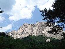 Ulsanbawi (peak) in Seoraksan National Park
 Biryong (Flying Dragon) Waterfalls in Seoraksan National Park.
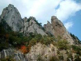 Seoraksan National Park
 Trying to shake Heundeulbawi (Rocking Rock) at Kyejo-am in Seoraksan National Park
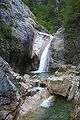 Cheondang Waterfall
See also
References
- ↑ "대한민국 구석구석 행복여행 - 설악산국립공원". korean.visitkorea.or.kr. Retrieved 2017-02-21.
- ↑ "설악산" (in Korean). Retrieved 2018-06-14.
- ↑ "설악산 울산바위" (in Korean). Retrieved 2018-06-14.
- ↑ "설악산 흔들바위" (in Korean). Retrieved 2018-06-14.
- ↑ "국가기록원 기록물뷰어". theme.archives.go.kr (in Korean). Retrieved 2018-03-24.
External links
| Wikimedia Commons has media related to Seoraksan. |

- Seoraksan National park