Mount Kumgang
| Mount Kumgang | |
|---|---|
 Location of Mount Kumgang. | |
| Highest point | |
| Elevation | 1,638 m (5,374 ft) |
| Geography | |
| Location | Mount Kumgang Tourist Region, North Korea |
| Korean name | |
| Chosŏn'gŭl | 금강산 |
|---|---|
| Hancha | 金剛山 |
| Revised Romanization | Geumgangsan |
| McCune–Reischauer | Kŭmgangsan |
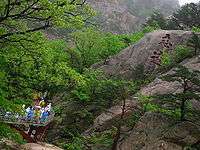

Mount Kumgang (Hangul: 금강산; RR: Geumgansan; MR: Kŭmgangsan; lit. Diamond Mountain) or the Kumgang Mountains are a mountain/mountain range, with a 1,638-metre-high (5,374 ft) Birobong peak, in Kangwon-do, North Korea. It is about 50 kilometres (31 mi) from the South Korean city of Sokcho in Gangwon-do. It is one of the best-known mountains in North Korea.[1] It is located on the east coast of the country, in Mount Kumgang Tourist Region, formerly part of Kangwŏn Province (38°35′N 128°10′E / 38.58°N 128.17°E). Mount Kumgang is part of the Taebaek mountain range which runs along the east of the Korean peninsula.
Seasonal names
Mount Kumgang has been known for its scenic beauty since ancient times[2][3][4] and is the subject of many different works of art. Including its spring name, Kŭmgangsan (Hangul: 금강산; Hanja: 金剛, Korean pronunciation: [kɯmɡaŋsʰan]), it has many different names for each season, but it is most widely known today in the Korean language as Kŭmgangsan. In summer it is called Pongraesan (봉래산, 蓬萊山: the place where a Spirit dwells); in autumn, Phung'aksan (풍악산, 楓岳山: hill of colored leaves, or 楓骨山: great mountain of colored leaves[5]); in winter, Kaegolsan (개골산, 皆骨山: stone bone mountain).
Formation
The creation of Mt. Geumgang is closely related to the unique climate and distinctive geological activity of the area.[6] Mt. Geumgang is a region where rain and snow fall relatively, and the climate varies depending on altitude and even east-west location.[6] The Geumgang geological layer is composed of several types of rocks belonging to the ancient geological period [7]The most widely distributed rocks are granites of two types (mica mixed and stained), with granite-gneissic fertilization zones being formed in some areas.[7] The rocks are transversely oriented and form a joint in various directions, forming unusual terrains and strange rocks, which have been formed as a result of erosion and erosion for a long period of crustal activity and weathering[6] [7][7]These effects were formed by the motion of the arch-shaped mass extinction that lasted from 10 million years to the present.[6]
Geography
Geumgang Mountain ranges from Gangwon-do, and Tongcheon-gun in Korea, and some areas extend to Inje-gun, Gangwon-do in the Republic of Korea,[8] 40 km to the east and west, 60 km to the north and south, and 530 km² to the back of Baekdudaegan . Based on the western part of the county, it is classified as the'Inner kumgang' in the west and the 'Outer kumgang' in the east. The area on the east side of the Yeongeum River is called 'Hae kumgang'. The main peak of Mt. Geumgang is Birobong, and more than 60,000 peaks over 1,000 meters. The combination of large and small peaks makes it difficult to measure. The ancestors were called 12,000 peaks.[8] Many scenic spots in the area are designated as natural monuments of the Democratic People's Republic of Korea. The southern part of the'Outer kumgang' is also called 'New gumgang'.[9] There are 11 'Outer kumgang', 8 'Inner kumgang' and 3 'Hae kumgang',[10] but not all of them have been opened yet.
.
Inner(내) kumgang
Since ancient times, 'kumgang' has been mainly used for the 'Inner kumgang',[11] located in the western part of the central pole, is the main pole of Mount Geumgang and many waterfalls.
- Outer Kŭmgang is noted for the large number of peaks. Chipson Peak (rock of ten thousand forms) is known for its many waterfalls.
- The Sea Kŭmgang area is known for the lagoons and stone pillars.
Outer(외) kumgang
It is located on the eastern side of the ‘Inner kumgang’ and covers the area along the east coast.
It includes many mountain peaks which are ‘Moonjoobong’,’Hobong’,’Sangdeungbong’,etc.
‘Kuryong(nine dragons) Falls’ in kuryongyeon is one of the three major waterfalls in ‘Joseon’ along with ‘Daeseung Falls’ in Seoraksan. [12] It is 74 meters in height and 4 meters in width. [12] The waterfall cliffs and the bottom are made of one granite mass. [12] ‘Bibbong Waterfall’ is 139 meters higher than this, and is named for its refreshing water stream. [13] There are many rocks in there and each rock contains unique legends. [14]
Environment
Much of the mountain is covered by mixed broadleaf and coniferous forest and protected in a 60,000 ha national park. Some 25,000 ha has been identified by BirdLife International as an Important Bird Area (IBA) because it supports endangered red-crowned cranes.[15]
Mount Kumgang Tourist Region
Starting in 1998, South Korean tourists were allowed to visit Mount Kumgang, initially travelling by cruise ship, and later more commonly by coach. In 2002, the area around the mountain was separated from Kangwŏn Province and organized as a separately-administered Tourist Region. The land route was opened in 2003. A rail link exists on the North Korean side up to the border, but no tracks are laid between Gangneung and the border in South Korea.
In 1998, there were 15,500 tourists in November and December, in 1999 there were 148,000, and in 2000 213,000. In 2001 tourist numbers dropped to 58,000 amidst disagreements over the access over land. As of 2002, almost 500,000 had visited the Mount Kumgang Tourist Region. Tourist numbers have since established themselves at about 240,000 a year. In June 2005, Hyundai Asan announced the one millionth South Korean visit to the area.[16]
The Mount Kumgang Tourist Region is thought to be one way for the North Korean government to receive hard currency from abroad. Therefore, the official currency of the tour is neither the South Korean won nor the North Korean won, but the US dollar. Since 2003, food and services to South Korean tourists are provided by some North Koreans. But most of the staff in the hotels are Chinese citizens of Korean heritage with Korean language skills. The area is developed by Hyundai Asan, which plans to expand the site with a proper ski resort to complement the current sleigh course, and complete golf courses. Many plans for expansion, however, are in their earliest stages.
On the morning of July 11, 2008, a 53-year-old South-Korean tourist was shot and killed while walking on the resort's beach. Park Wang-ja entered a military area by crossing over a sand dune and was shot twice by North Korean soldiers. North Korea claimed that sentries had no choice but to shoot her because, despite their order to stop, she fled. South Korea demanded an on-the-spot survey, but North Korea declined it, claiming all the facts were clear and all responsibilities were the victim's and South Korea's. Due to the shooting, South Korea temporarily suspended all trips to Mount Kumgang.[17] In March 2010, the DPRK government warned of "extraordinary measures" if the tourism ban were not lifted.[18] On April 23, 2010, the North Korean government seized 5 properties owned by South Korea at the resort, saying that it was done "in compensation for the damage the North side suffered due to the suspension of the tour for a long period." In seizing the properties, North Korea also alluded to the Baengnyeong incident, showing displeasure with South Korea blaming North Korea for the sinking of the ship.[19] Since April 2010, North Korea is now permitting companies to run tours from the North Korean side,[20] making it appear increasingly unlikely that tours will be resumed from the South. However, on October 1, 2010, news reports said, "Red Cross officials from the two Koreas agreed Friday to hold reunions for families separated by the Korean War amid mixed signals from North Korea on easing tensions over the sinking of a South Korean warship. One hundred families from each country will attend the meetings from Oct. 30 to Nov. 5 at a hotel and reunion center at the North's scenic Diamond Mountain resort, Unification Ministry spokeswoman Lee Jong-joo said."[21] As of September 2011 North Korea have begun operating cruises directly from Rason in north-eastern North Korea, to the port in Mount Kumgang, offering visitors the chance to stay in the resorts previously run by the south. Although they are aimed primarily at Chinese guests, western companies are also offering the tours .[22][23]
History
Koreans have perceived Geumgansan as their muse since well before the Middle Ages. [24] Practically every poet and artist who lived during the Joseon dynasty (1392-1910) made a pilgrimage to Geumgangsan. [24] The division of the Korean peninsula in 1950 resulted in the South Korean people finding themselves unable to visit this beloved mountain for the better part of 50 years. [25] The 155-mile-long (249 km) barbed-wire fence erected as part of the DMZ (Demilitarized zone) separating the two Koreas proved to be an obstacle stronger than any other barrier.[25] It was in 1894 the British writer Isabella Bird Bishop referred to it in her travelogue as "Diamond Mountain".[25]
See also
Notes and references
- ↑ The Associated Press (September 22, 2000). "North Korea approves Japanese tours to Mount Kumgang". CNN.
- ↑ "North Korea Relief". Encyclopædia Britannica.
Mount Kŭmgang (5,374 feet), is renowned for its scenic beauty.
- ↑ Susan Chira (February 2, 1989). "The two Koreans agree to develop resort in North". New York Times.
- ↑ Aidan Foster-Carter (March 30, 2001). "PYONGYANG WATCH Hyundai and North Korea: What now?". Asia Times Online.
Kumgangsan - the famously scenic Diamond Mountains just above the DMZ
- ↑ Yi I's book, 풍악행, refers to the mountain by this name.
- 1 2 3 4 "�����һ��� �ݰ���". fr.catholic.or.kr. Retrieved 2018-03-17. replacement character in
|title=at position 1 (help) - 1 2 3 4 ":::: 가슴에 남는 여행-금강산관광 | 개성관광 :::: (a)". www.mtkumgang.com. Retrieved 2018-03-17.
- 1 2 금강산. www.koreasanha.net (in Korean). Retrieved 2018-03-24.
- ↑ "Archived copy" 금강산 기행문을 쓰면서(1). www.songpr.com (in Korean). Archived from the original on 28 April 2013. Retrieved 24 March 2018.
- ↑ "[국내여행] 만 이천 봉 곳곳마다 그리움 사무쳐" (in Korean). Retrieved 2018-03-24.
- ↑ "[북강원 금강산 생태탐사②] 2. 초여름 금강산 식물". 강원일보 홈페이지 (in Korean). Retrieved 2018-03-24.
- 1 2 3 "구룡폭포와 구룡연 이름의 유래 - 문화콘텐츠닷컴". culturecontent.com (in Korean). Retrieved 2018-04-07.
- ↑ "비봉폭포(飛鳳瀑布) - 한국민족문화대백과사전". encykorea.aks.ac.kr (in Korean). Retrieved 2018-04-07.
- ↑ "금강산의 전설1 - 문화콘텐츠닷컴". www.culturecontent.com (in Korean). Retrieved 2018-04-07.
- ↑ "Mount Kumgang". Important Bird Areas factsheet. BirdLife International. 2013. Retrieved 2013-05-12.
- ↑ Hankooki.com
- ↑ "Chosun Ilbo".
- ↑ "North Korea issues warning over Mount Kumgang tour ban". BBC News. 25 March 2010.
- ↑ "North Korea 'to seize property at Kumgang resort'". BBC News. April 23, 2010.
- ↑ "North Korea 'two new resorts open to public'". Young Pioneer Tours.
- ↑ "NPR".
- ↑ "Young Pioneer Tours, DPRK". Archived from the original on 2012-03-23.
- ↑ "Kumgangsan DPRK - hike in North Korea & discover this beautiful mountain area". www.north-korea-travel.com.
- 1 2 Yoo, Myeonng-jong (2008). 100 Cultural Symbols of Korea (1 ed.). 431, king’s garden office hotel 3rd complex, 72, naesoo-dong, Jongno-gu. seoul, korea: Discovery Media.
- 1 2 3 Yoo, Myeonng-jong (September 2008). 100 Cultural Symbols of Korea (1 ed.). 431, king’s garden office hotel 3rd complex, 72, naesoo-dong, Jongno-gu. seoul, korea: Discovery Media. p. 19.
External links
| Wikimedia Commons has media related to Kumgangsan. |
| Wikivoyage has a travel guide for Mount Kumgang. |
Coordinates: 38°39′24″N 128°06′18″E / 38.65667°N 128.10500°E