Mount Sabyinyo
| Mount Sabyinyo | |
|---|---|
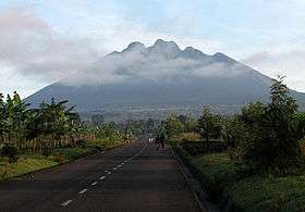 Sabyinyo from the south | |
| Highest point | |
| Elevation | 3,669 m (12,037 ft) |
| Coordinates | 01°24′S 29°36′E / 1.400°S 29.600°ECoordinates: 01°24′S 29°36′E / 1.400°S 29.600°E |
| Geography | |
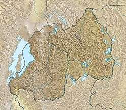 Mount Sabyinyo Location in Rwanda, on the DRC/Rwanda/Uganda border | |
| Location | Democratic Republic of the Congo–Rwanda–Uganda |
| Parent range | Virunga Mountains |
| Geology | |
| Mountain type | Stratovolcano |
| Last eruption | Pleistocene[1] |
Mount Sabyinyo ("Sabyinyo" is derived from the Kinyarwanda word "Iryinyo", meaning "tooth"; also "Sabinyo, Sabinio") is an extinct volcano in eastern Africa in the Virunga Mountains. It is north-east of Lake Kivu, one of the African Great Lakes, and west of Lake Bunyonyi in Uganda. The summit of the mountain, at 3,669 metres (12,037 ft), marks the intersection of the borders of the Democratic Republic of the Congo (DRC), Rwanda, and Uganda. It also is within the adjoining national parks established by these countries: Virunga National Park in the DRC, the Volcanoes National Park in Rwanda, and Mgahinga Gorilla National Park in Uganda.
The slopes of Mt. Sabyinyo are a habitat for the critically endangered mountain gorilla. The mountain carries the local nickname "Old Man's Teeth" because its serrated summit resembles worn teeth in a gum line (in contrast to the perfect conical summits of the adjacent mountains in this range).[2]
References
- ↑ "Sabinyo". Global Volcanism Program. Smithsonian Institution. Retrieved 13 September 2016.
- ↑ Briggs, Philip (2013). Uganda, Bradt Travel Guides. Bradt. p. 268. Retrieved 14 September 2016.
External links
| Wikimedia Commons has media related to Mount Sabyinyo. |