Mount Omoto
| Mount Omoto | |
|---|---|
| 於茂登岳 | |
 Mount Omoto | |
| Highest point | |
| Elevation | 525.5 m (1,724 ft) |
| Prominence | 525 metres (1,722 ft) |
| Coordinates | 24°25′38″N 124°11′00″E / 24.42722°N 124.18333°ECoordinates: 24°25′38″N 124°11′00″E / 24.42722°N 124.18333°E |
| Geography | |
 Mount Omoto | |
| Parent range | Omoto Range |
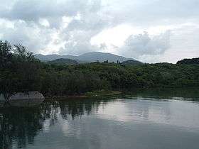
Mount Omoto (於茂登岳 Omoto-dake) is a mountain located on Ishigaki Island in Okinawa, Japan. Together with Kabira Bay it is a nationally designated Place of Scenic Beauty.[1][2]
Overview
At 525.5 metres (1,724 ft) above sea level, Mount Omoto is the tallest mountain in Okinawa Prefecture. It is located on the island of Ishigaki, near the center of the Omoto Mountain Range, which runs east to west along the northern coast of the island.
Geologically, it is formed by granite from the Neogene Period. The Miyara River flowing from the northeast side and the Nagura River flowing from the south side of the mountain are vital sources of drinking and agricultural water on the island.
References
- ↑ "川平湾及び於茂登岳". Agency for Cultural Affairs. Archived from the original on 22 July 2012. Retrieved 15 February 2012.
- ↑ "Kabira Bay and Mount Omoto". Agency for Cultural Affairs. Retrieved 15 February 2012.
This article is issued from
Wikipedia.
The text is licensed under Creative Commons - Attribution - Sharealike.
Additional terms may apply for the media files.