Mount Ollivier
| Mount Ollivier | |
|---|---|
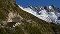
 Mueller Hut and the summit of Mount Ollivier | |
| Highest point | |
| Elevation | 1,933 m (6,342 ft) |
| Coordinates | 43°43′32″S 170°03′52″E / 43.7256°S 170.0645°ECoordinates: 43°43′32″S 170°03′52″E / 43.7256°S 170.0645°E |
| Geography | |
 Mount Ollivier Location of Mount Ollivier in the Southern Alps, New Zealand | |
| Location | Aoraki/Mount Cook National Park |
| Parent range | Sealy Range |
Mount Ollivier is a 1,933 m (6,342 ft) mountain in the Canterbury Region of New Zealand.[1] It is a peak in the Sealy Range, about 2.5 km (1.6 mi) west of Mount Cook Village. The peak is named after mountaineer Arthur Ollivier, who died in 1897.[2]
Mount Ollivier was Sir Edmund Hillary's first major climb, in 1939. After his death in 2008, there was a proposal to rename the peak Mount Hillary as a memorial, a suggestion opposed by Arthur Ollivier's family.[2]
Since the establishment of a tramping track to Mueller Hut, not far below the summit, the peak is now one of the easiest accessible mountains in the park. The section between Mueller Hut and the summit is a rock scramble rather than a mountain climb.[3]
 Ascent to Mueller Hut and Mount Ollivier
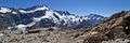 Mueller Hut with Mount Sefton and Mount Cook
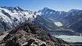 View from the summit of Mount Ollivier
References
- ↑ "Place name detail: Mount Ollivier". New Zealand Gazetteer. Land Information New Zealand. Retrieved 25 April 2009.
- 1 2 Booker, Jarrod (18 January 2008). "Renaming peak for Sir Ed meets resistance". The New Zealand Herald. Retrieved 25 April 2009.
- ↑ "Mueller Hut Route". Department of Conservation. Retrieved 2016-09-21.
This article is issued from
Wikipedia.
The text is licensed under Creative Commons - Attribution - Sharealike.
Additional terms may apply for the media files.