Mount Mystery
| Mount Mystery | |
|---|---|
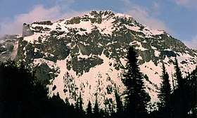 Mount Mystery's west face | |
| Highest point | |
| Elevation | 7,639 ft (2,328 m) [1] |
| Prominence | 1,119 ft (341 m) [1] |
| Coordinates | 47°47′45″N 123°13′17″W / 47.795903°N 123.221465°WCoordinates: 47°47′45″N 123°13′17″W / 47.795903°N 123.221465°W [1] |
| Geography | |
 Mount Mystery Location of Mount Mystery in Washington  Mount Mystery Mount Mystery (the US) | |
| Location | Jefferson County, Washington, United States |
| Parent range | Olympic Mountains |
| Topo map | USGS Mount Deception |
| Geology | |
| Age of rock | Eocene |
| Mountain type | Tilted pillow Basalt |
| Climbing | |
| Easiest route | Scrambling |
Mount Mystery is a prominent summit of the Olympic Mountains and is located in Jefferson County of Washington state. It is located within Olympic National Park on the Olympic Peninsula. At 7,639 feet (2,328 m) high, Mount Mystery is the sixth highest peak of the Olympic Mountains, after Mount Olympus, Mount Deception, Mount Constance, Mount Johnson, and Inner Constance.[2] Its nearest higher peak is Mount Deception at 1.32 mi (2.12 km) to the north-northwest. Little Mystery (6941 ft) is a subsidiary summit south of Mount Mystery.
Mount Mystery is located in the eastern portion of the Olympic Mountains just south of Mount Deception at the headwaters of Deception Creek. This location puts it in the rain shadow of the Olympic Range, resulting in far less precipitation than Mount Olympus and the western Olympics receive.
Mount Mystery sits on the boundary between the drainage basins of the Dungeness River, to the north, and the Dosewallips River to the east. Deception Creek, a tributary of the Dosewallips River, drains the east and west slopes of Mount Mystery, including a small melting glacier on the east side referred to colloquially as Mystery Glacier.
History
Mount Mystery was given its name circa 1915 by G.A. Whitehead of the U.S. Forest Service because he admired its regal appearance in foggy weather.[3]
Climate
Mount Mystery is located in the marine west coast climate zone of western North America. Most weather fronts originate in the Pacific Ocean, and travel northeast toward the Olympic Mountains. As fronts approach, they are forced upward by the peaks of the Olympic Range, causing them to drop their moisture in the form of rain or snowfall (Orographic lift). As a result, the Olympics experience high precipitation, especially during the winter months in the form of snowfall. During winter months, weather is usually cloudy, but, due to high pressure systems over the Pacific Ocean that intensify during summer months, there is often little or no cloud cover during the summer. Because of maritime influence, snow tends to be wet and heavy, resulting in high avalanche danger.
Recreation
While not a particularly technical climb, Mount Mystery is steep and exposed. If a climber falls and does not arrest immediately, loose rock and rotten snow may make it difficult to stop falling for some distance. The nearby Needles are typically regarded as providing better, and somewhat more difficult, mountaineering objectives in the Royal Basin area.
References
- 1 2 3 "Mount Mystery". Peakbagger.com.
- ↑ "Olympic Mountains". Peakbagger.com.
- ↑ "Mount Mystery". Peakware.com.
External links
- "Olympic National Park". National Park Service.