Mount Myōken (Tajima)
| Mount Myōken | |
|---|---|
| 妙見山 | |
 Mount Myōken from eastside | |
| Highest point | |
| Elevation | 1,135.5 m (3,725 ft) |
| Listing | List of mountains and hills of Japan by height |
| Coordinates | 35°24′39″N 134°38′41″E / 35.41083°N 134.64472°ECoordinates: 35°24′39″N 134°38′41″E / 35.41083°N 134.64472°E |
| Naming | |
| Pronunciation | [mjoːkensaɴ] |
| Geography | |
| Location | On the border of Yabu, Hyogo and Kami, Mikata, Hyogo, Japan |
| Parent range | Chūgoku Mountains |
Mount Myōken (妙見山 Myōken-san) is a 1,135.5 m (3,725 ft) mountain on the border of Yabu and Kami, Mikata, Hyogo, Japan. This mountain is one of Hyōgo 50, and a part of Hyonosen-Ushiroyama-Nagisan Quasi-National Park. The other name of this mountain is Mount Ishihara.
Outline
Mount Myōken is a mountain on the eastern edge of the Chūgoku Mountains. Nikkōin temple is located at the base of the mountain. Originally, the temple was halfway up the mountain,but the Haibutsu-Kishaku Order issued during the Meiji-era forced the move.
Route
This mountain has major two routes to the top. One is from Ishihara Bus Stop of Tantō Bus. The other is from Mount Sobu. From Ishihara Bus Stop, it takes about three hours to the top.
Access
- Ishihara Bus Stop of Tantō Bus
Gallery
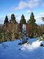 The top of Mount Myōken (12/2008)
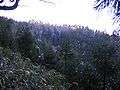 Mount Myōken near the top (12/2008)
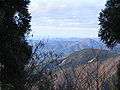 Mount Sobu from the top of Mount Myōken (12/2008)
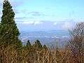 Hidaka Plain from the top of Mount Myōken (12/2008)
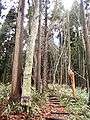 Forest of Mount Myōken (12/2008)
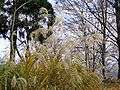 A view in the middle of Mount Myōken (12/2008)
 At the Nikkōin temple at the foot of Mount Myōken (12/2008)
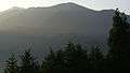 Mount Myōken from northside (07/2006)
References
This article is issued from
Wikipedia.
The text is licensed under Creative Commons - Attribution - Sharealike.
Additional terms may apply for the media files.