Mount Stanley
| Mount Stanley | |
|---|---|
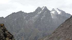 Mount Stanley from left to right: Moebius Peak, Elena Peak, Savoia Peak, Alexandra Peak, Margherita Peak | |
| Highest point | |
| Elevation | 5,109 m (16,762 ft) |
| Prominence |
3,951 m (12,963 ft) Ranked 28th |
| Isolation | 830 kilometres (520 mi) |
| Listing |
Country high point Ultra |
| Coordinates | 0°23′09″N 29°52′18″E / 0.38583°N 29.87167°ECoordinates: 0°23′09″N 29°52′18″E / 0.38583°N 29.87167°E |
| Geography | |
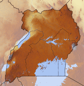 Mount Stanley Location in Uganda (on the border with Democratic Republic of the Congo) | |
| Location | Democratic Republic of the Congo—Uganda |
| Parent range | Ruwenzori Range |
| Climbing | |
| First ascent | 1906 by Duke of the Abruzzi and party |
| Easiest route | rock/snow climb |
Mount Stanley is a mountain located in the Rwenzori range. With an elevation of 5,109 m (16,763 ft), it is the highest mountain of both the Democratic Republic of the Congo and Uganda, and the third highest in Africa, after Kilimanjaro (5,895 m) and Mount Kenya (5,199 m). The peak and several other surrounding peaks are high enough to support glaciers. Mount Stanley is named for the journalist and explorer, Sir Henry Morton Stanley. It is part of the Rwenzori Mountains National Park, a UNESCO world Heritage Site.[1]
Mt. Stanley consists of two twin summits and several lower peaks:
Peak metres feet Margherita Peak 5,109 16,763 Alexandra 5,091 16,703 Albert 5,087 16,690 Savoia 4,977 16,330 Ellena 4,968 16,300 Elizabeth 4,929 16,170 Phillip 4,920 16,140 Moebius 4,916 16,130 Great Tooth 4,603 15,100
Expeditions
First Recorded Successful Attempt
The first recorded ascent of Mt. Stanley was in 1906 by Luigi Amedeo, J. Petigax, C. Ollier, and J. Brocherel. Margherita Peak is named after Queen Margherita of Italy.[2]
References
- ↑ UNESCO World Heritage Centre
- ↑ Peter Bridges, ‘A Prince of Climbers’, Virginia Quarterly Review, 76-1 (Winter 2000), 38–51.