Rwenzori Mountains
| Rwenzori Mountains | |
|---|---|
 | |
| Highest point | |
| Peak | Mount Stanley |
| Elevation | 5,109 m (16,762 ft) |
| Coordinates | 00°23′09″N 29°52′18″E / 0.38583°N 29.87167°ECoordinates: 00°23′09″N 29°52′18″E / 0.38583°N 29.87167°E |
| Dimensions | |
| Length | 120 km (75 mi) |
| Geography | |
 Rwenzori Mountains | |
| Country | Uganda, Democratic Republic of the Congo |
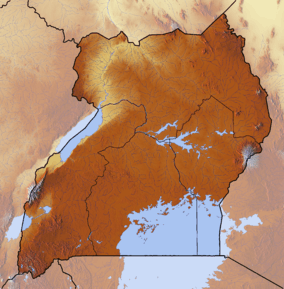
The Rwenzori Mountains, previously called the "Ruwenzori Range" (spelling changed around 1980 to conform more closely with the local name Rwenjura), is a mountain range of eastern equatorial Africa, located on the border between Uganda and the Democratic Republic of the Congo (DRC). These mountains support glaciers and are one source of the river Nile.[1]
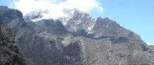
The Rwenzori Mountains reach heights up to 5,109 metres (16,762 ft). The highest Rwenzori peaks are permanently snow-capped. The Rwenzori Mountains National Park and Virunga National Park are located in the range.
Geology
The mountains formed about three million years ago in the late Pliocene epoch and are the result of an uplifted block of crystalline rocks including gneiss, amphibolite, granite and quartzite.[2]
This uplift divided the paleolake Obweruka and created three of the present-day African Great Lakes: Lake Albert, Lake Edward,[2] and Lake George.[3]
The range is about 120 kilometres (75 mi) long and 65 kilometres (40 mi) wide. It consists of six massifs separated by deep gorges: Mount Stanley (5,109 metres (16,762 ft)), Mount Speke (4,890 metres (16,040 ft)), Mount Baker (4,843 metres (15,889 ft)), Mount Emin (4,798 metres (15,741 ft)), Mount Gessi (4,715 metres (15,469 ft)) and Mount Luigi di Savoia (4,627 metres (15,180 ft)).[4] Mount Stanley has several subsidiary summits, with Margherita Peak being the highest point.
Human history
The mountains are occasionally identified with the legendary "Mountains of the Moon", depicted in Antiquity as the source of the Nile River.[1]
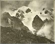
Photographer Vittorio Sella took a number of photographs of the Rwenzori Mountains during the late 19th and early 20th centuries, documenting the retreat of the range's glaciers.[5] Sella's photographic work is conserved at the Museo Nazionale della Montagna in Turin and at the Istituto di Fotografia Alpina Vittorio Sella in Biella, both in Italy. The Makerere University, Uganda, also has a selection of his images.[6]
The first traverse of the six massifs of the Rwenzori Mountains was done in 1975, starting on 27 January and ending on 13 February. The traverse was done by Polish climbers Janusz Chalecki, Stanisław Cholewa and Leszek Czarnecki, with Mirosław Kuraś accompanying them on the last half of the traverse.[7]
Natural history
Flora
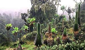
The Rwenzori Mountains are known for their vegetation, ranging from tropical rainforest through alpine meadows to snow. The range supports its own species and varieties of giant groundsel and giant lobelia and even has a 6 metres (20 ft) tall heather covered in moss that lives on one of its peaks. Most of the range is now a World Heritage Site and is covered jointly by the Rwenzori Mountains National Park in south-western Uganda and the Virunga National Park in the eastern DRC.[4]
There is no water shortage in the Rwenzori; yet, several members of the afroalpine family resemble species that normally thrive in desert climates. The reason lies in their similar water economy. Water is not always readily available to the afroalpine plants when they need it. In addition, nightly frosts affect the sap transport in the plants and the intake of water by its roots. As the day begins, the air temperature and radiation level rise rapidly, putting strenuous demands on the exposed parts of the plants as they try to meet the transpiration demands of the leaves and maintain a proper water balance. To counter the effects of freezing, the afroalpine plants have developed the insulation systems that give them such a striking appearance. These adaptations become more prominent as the altitude increases.[6]
There are five overlapping vegetation zones in the Rwenzori Mountains: the evergreen forest zone (up to 2,800 metres (9,200 ft)); the bamboo zone (2,800 to 3,300 metres (9,200 to 10,800 ft)); the heather zone (3,000 to 3,800 metres (9,800 to 12,500 ft)); the alpine zone (3,500 to 4,500 metres (11,500 to 14,800 ft)); and, the nival zone (4,400 to 5,000 metres (14,400 to 16,400 ft)). At higher altitudes, some plants reach an unusually large size, such as lobelia and groundsels. The vegetation in the Rwenzori Mountains is unique to equatorial alpine Africa.[8]
| Meters Order | 1500 | 2000 | 2500 | 3000 | 3200 | 3400 | 3600 | 3800 | 4000 | 4200 | 4400 | 4600 | 4800 | 5000 | 5100 |
|---|---|---|---|---|---|---|---|---|---|---|---|---|---|---|---|
| Lamiales | Mimulopsis elliotii Mimulopsis arborescens | ||||||||||||||
| Rosales | Prunus africana | Hagenia abyssinica | |||||||||||||
| Alchemilla subnivalis Alchemilla stuhlmanii Alchemilla triphylla Alchemilla johnstonii | |||||||||||||||
| Alchemilla argyrophylla | |||||||||||||||
| Fabales | Albizia gummifera | ||||||||||||||
| Cornales | Alangium chinense | ||||||||||||||
| Malpighiales | Casearia battiscombei Croton macrostachyus Neoboutonia macrocalyx Symphonia globulifera | Hypericum sp | |||||||||||||
| Hypericum revolutum Hypericum bequaertii | |||||||||||||||
| Asparagales | Scadoxus cyrtanthiflorus | ||||||||||||||
| Disa stairsii | |||||||||||||||
| Asterales | Dendrosenecio erici-rosenii | ||||||||||||||
| Dendrosenecio adnivalis Helichrysum sp. Lobelia bequaertii Lobelia wollastonii | Helichchrysum guilelmii | ||||||||||||||
| Helichchrysum stuhlmanii | |||||||||||||||
| Senecio transmarinus Senecio mattirolii | |||||||||||||||
| Apiales | Peucedanum kerstenii | ||||||||||||||
| Myrtales | Syzygium guineense | ||||||||||||||
| Sapindales | Allophylus abyssinicus | ||||||||||||||
| Gentianales | Tabernaemontana sp. | Galium ruwenzoriense | |||||||||||||
| Ericales | Pouteria adolfi-friedericii | Erica arborea Erica trimera | |||||||||||||
| Erica silvatica Erica johnstonii | |||||||||||||||
| Brassicales | Subularia monticola | ||||||||||||||
| Primulales | Rapanea rhododendroides | ||||||||||||||
| Ranunculales | Ranunculus oreophytus Arabis alpina | ||||||||||||||
| Santalales | Strombosia scheffleri | ||||||||||||||
| Poales | Yushania alpina | Carex runssoroensis Festuca abyssinica | |||||||||||||
| Poa ruwenzoriensis | |||||||||||||||
| Lecanorales | Usnea | ||||||||||||||
| Order Meters | 1500 | 2000 | 2500 | 3000 | 3200 | 3400 | 3600 | 3800 | 4000 | 4200 | 4400 | 4600 | 4800 | 5000 | 5100 |
Glacial recession
An ongoing concern is the impact of climate change on Rwenzori's glaciers. In 1906, the Rwenzori had 43 named glaciers distributed over six mountains with a total area of 7.5 square kilometres (2.9 sq mi), about half the total glacier area in Africa. By 2005, less than half of these were still present, on only three mountains, with an area of about 1.5 square kilometres (0.58 sq mi). Recent scientific studies, such as those by Richard Taylor of University College London, have attributed this retreat to global climate change and have investigated the impact of this change on the mountain's vegetation and biodiversity.[11][12]
See also
Notes
- 1 2 Scheffel, Richard L.; Wernet, Susan J., eds. (1980). Natural Wonders of the World. United States of America: Reader's Digest Association, Inc. p. 327. ISBN 0-89577-087-3.
- 1 2 "Climate Change and the Aquatic Ecosystems of the Rwenzori Mountains". Makerere University and University College London. 15 September 2007. Retrieved 2 February 2014.
- ↑ Wayland, E. J. (July–December 1934). "Rifts, Rivers, Rains and Early Man in Uganda". Journal of the Royal Anthropological Institute. Royal Anthropological Institute of Great Britain and Ireland. 64: 333–352. doi:10.2307/2843813. JSTOR 2843813.
- 1 2 "Rwenzori Mountains National Park". Rwenzori Abruzzi. 27 May 2006. Archived from the original on 2008-03-05. Retrieved 6 May 2008.
- ↑ "Vittorio Sella". Rwenzori Abruzzi Centenary Celebrations. 2006. Archived from the original on 2008-05-08. Retrieved 2008-08-09.
- 1 2 Flowers of the Moon, Afroalpine vegetation of the Rwenzori Mountains, Schutyser S., 2007, 5 Continents Editions, ISBN 978-88-7439-423-4.
- ↑ Wielka Grań Ruwenzori 1975, Wojtera T., Taternik iss 3. 1976.
- 1 2 Linder, H. Peter; Gehrke, Berit (2 March 2006). "Common plants of the Rwenzori, particularly the upper zones" (PDF). Institute for Systematic Botany, University of Zurich. Archived from the original (PDF) on 30 May 2008. Retrieved 6 June 2017.
- ↑ "RWENZORI MOUNTAINS NATIONAL PARK, UGANDA". Protected Areas and World Heritage. United Nations Environment Programme. March 1994. Archived from the original on 25 March 2008. Retrieved 8 May 2008.
- ↑ "Forest Resources of Tropical Africa". Tropical Forest Resources Assessment Project (reprint ed.). Food and Agriculture Organization of the United Nations. 1984. UN 32/6.1301–78–04. Retrieved 12 May 2008.
- ↑ Tom Knudson, [In the Mountains of the Moon, A Trek to Africa’s Last Glaciers], Yale Environment 360 Report, 4 Feb 2010
- ↑ [Rwenzori Glaciers (East Africa)], Tropical Glaciology Group, Innsbruck University
References
- Glaciers of the Middle East and Africa, Williams, Richard S., Jr. (editor) In: U. S. Geological Survey Professional Paper, 1991, pp.G1-G70
- Guide to the Ruwenzori, Osmaston,H.A., Pasteur,D. 1972, Mountain Club of Uganda. 200 p.
- Recession of Equatorial Glaciers. A Photo Documentation, Hastenrath, S., 2008, Sundog Publishing, Madison, WI, ISBN 978-0-9729033-3-2, 144 pp.
- Tropical Glaciers, Kaser, G., Osmaston, H.A. 2002, Cambridge University Press, UK. 207 p.
- Ruwenzori, de Filippi, F. 1909. Constable, London. 408 p.
- Greenpeace article "The Death of the Ice Gigantaurs"
- BBC Article "Fabled ice field set to vanish"
- Dr Taylor's Homepage, with information about the impact of climate change on Rwenzori.
- Kaser et al. 2006, in International Book of Climatology 24: 329–339 (2004)
External links
| Wikimedia Commons has media related to Ruwenzori Range. |
| Wikisource has the text of the 1920 Encyclopedia Americana article Ruwenzori. |
- World Wildlife Fund, ed. (2001). "Ruwenzoris". WildWorld Ecoregion Profile. National Geographic Society. Archived from the original on 2010-03-08.
- UWM.edu: 1937 aerial photographs of Rwenzori Mountains — University of Wisconsin-Milwaukee Libraries Digital Collections.
