Mount Iwakura
| Mount Iwakura | |
|---|---|
| 岩倉山 | |
 The Shrine on the Top of the Mount Iwakura | |
| Highest point | |
| Elevation | 488.4 m (1,602 ft) |
| Coordinates | 34°48′N 135°19′E / 34.800°N 135.317°E |
| Naming | |
| Pronunciation | [iɰakɯɾajama] |
| Geography | |
| Location | Takarazuka, Hyōgo, Japan |
| Parent range | Rokko Mountains |
Mount Iwakura (岩倉山 Iwakura-yama) is a 488.4-metre-high (1,602 ft) mountain in Takarazuka, Hyōgo Prefecture, Japan.
Outline
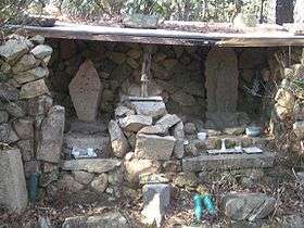
Mount Iwakura is a part of Setonaikai National Park. The mountain is a peak on the eastern ridge of the Rokko Mountains. It is said that the mountain received its name because of the stone shrine (Iwakura) on the top of the mountain.
Access
References
- Shozo Tamaki, Rokkosan Hakubutsushi, Kobe Shimbun Shuppan Center
- Official Home Page of Setonaikai National Park
- Official Home Page of the Geographical Survey Institute in Japan
This article is issued from
Wikipedia.
The text is licensed under Creative Commons - Attribution - Sharealike.
Additional terms may apply for the media files.