Mount Hor
Mount Hor (Hebrew: הֹר הָהָר, Hor Ha-Har) is the name given in the Old Testament to two distinct mountains. One borders the land of Edom in the area south of the Dead Sea, and the other is by the Mediterranean Sea at the Northern border of the Land of Israel. The first Mount Hor is especially significant to the Israelites as Aaron the high priest, brother of Moses, died there.
Mount Hor in Edom (Mount Harun)

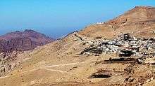
This Mount Hor is situated "in the edge of the land of Edom" (Numbers 20:23 and 33:37) and was the scene of Aaron's divestiture, death and burial.[1] The exact location of Mount Hor has been the subject of debate, but based on the writing of Josephus[2] it has customarily been identified with the Jebel Nebi Harun ("Mountain of the Prophet Aaron" in Arabic), a twin-peaked mountain 4780 feet above sea-level (6072 feet above the Dead Sea) in the Edomite Mountains on the east side of the Jordan-Arabah valley. On the summit is a shrine, the Tomb of Aaron, said to cover the grave of Aaron.
Some investigators at the turn of the 20th century dissented from this identification: for example, Henry Clay Trumbull preferred the Jebel Madara, a peak about 15 miles northwest of 'Ain Kadis (Kadesh Barnea), near the modern border between Israel and Egypt.
Northern Mount Hor
Another Mount Hor is mentioned in the Book of Numbers,[3] defining the northern boundary of the Land of Israel. It is traditionally identified as the Nur or Amanus Mountains.[4] When in the Second Temple period, Jewish authors seeking to establish with greater precision the geographical definition of the Promised Land, began to construe Mount Hor as a reference to the Amanus range of the Taurus Mountains, which marked the northern limit of the Syrian plain.[5] Rabbinic writings [6]also declare Amanah a boundary of the land of Israel, saying "from the mountains of Amanah, to the river of Egypt; whatever is within that line belongs to the land of Israel: but, whatever is without that line, is without the land."[7][8]
Mount Hor is also called Amanah, and is known as Mount Manus in the Jerusalem Targums, and Umanis in Targum Jonathan.[9] It is not to be confused with Mount Amana in the Anti-Lebanese Mountains.
References
- ↑ Numbers 20:22-28
- ↑ Antiq. 4:4:6.
- ↑ Num. 34:7-8.
- ↑ Joseph H. Hertz ed., The Pentateuch and Haftorahs: Hebrew Text English Translation and Commentary Edition: 2, Soncino Press, 1988
- ↑ Bechard, Dean Philip (1 January 2000). Paul Outside the Walls: A Study of Luke's Socio-geographical Universalism in Acts 14:8-20. Gregorian Biblical BookShop. pp. 203–205. ISBN 978-88-7653-143-9.
In the Second Temple period, when Jewish authors were seeking to establish with greater precision the geographical definition of the Land, it became customary to construe “Mount Hor” of Num 34:7 as a reference to the Amanus range of the Taurus Mountains, which marked the northern limit of the Syrian plain (Bechard 2000, p. 205, note 98.)
- ↑ See Mishna Sheviis 6:1.
- ↑ Wells & Calmet 1817, p. 316;, Canaan.
- ↑ Cf. Bloch & Bloch 1995, p. 13 - Bloch, A.; Bloch, C. (1995). The Song of Songs: A New Translation with an Introduction and Commentary. New Translation. University of California Press. ISBN 978-0-520-22675-3. Retrieved 26 July 2017.
- ↑ Wells, E.; Calmet, A. (1817). "Amanah". Sacred geography; or, A companion to the Holy Bible. Calmet's Dictionary of the Holy Bible (Revised ed.). Charlestown: Samuel Etheridge, Jr. p. 276f. Retrieved 26 July 2017.
![]()
External links
| Wikimedia Commons has media related to Mount Hor. |
| Previous Station: Kadesh |
The Exodus Stations list |
Next Station: Zalmonah |
Coordinates: 30°19′01″N 35°24′25″E / 30.31694°N 35.40694°E