Mount Hicks (New Zealand)
| Mount Hicks | |
|---|---|
| Saint David's Dome | |
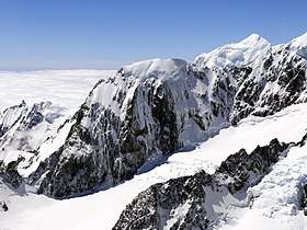 Mount Hicks in the center of the image, with Mount Vancouver in background | |
| Highest point | |
| Elevation | 3,216 m (10,551 ft) |
| Prominence | 56 m (184 ft) |
| Isolation | 0.9 km (0.56 mi) |
| Parent peak | Mount Dampier |
| Coordinates | 43°35′16″S 170°07′44″E / 43.587734°S 170.12882°ECoordinates: 43°35′16″S 170°07′44″E / 43.587734°S 170.12882°E [1] |
| Geography | |
 Mount Hicks | |
| Parent range | Southern Alps |
| Climbing | |
| First ascent | February 9, 1906 by Newton, Low und Alec Graham[2] |
Mount Hicks (also known as Saint David's Dome) is a mountain in the Southern Alps in Aoraki/Mount Cook National Park on the South Island of New Zealand. The mountain is 3,216 metres (10,551 ft) high. It is above the Hooker Glacier, in the vicinity of Mount Cook.
The mountain was first ascended in 1906.[2] The starting point for ascents is the Empress hut. From the south face of Mount Hicks there are several possible routes, including the Dingle-Button route.[3]
Notes
- ↑ "Mount Hicks, New Zealand". Peakbagger.com. Retrieved 2015-01-10.
- 1 2 Bob McKerrow (2009-07-02). "The Official Ebenezer Teichelmann Blog". Retrieved 2010-03-28.
- ↑ Neil Wood (December 2003). "Dingle-Button Route on Mt Hicks". mountainz.co.nz. Archived from the original on 26 May 2010. Retrieved 2010-03-28.
External links
- Collections of the Alexander Turnbull Library, ed. (1895). "Mount Cook from Fitzgerald's Saddle.jpg". Retrieved 2010-03-28. Image of Mount Hicks and Mount Cook, Mount Hicks is to the left of the middle in the background
This article is issued from
Wikipedia.
The text is licensed under Creative Commons - Attribution - Sharealike.
Additional terms may apply for the media files.