Mount Gilbert (Nevada)
| Mount Gilbert | |
|---|---|
 | |
| Highest point | |
| Elevation | 11,125 ft (3,391 m) NAVD 88[1] |
| Prominence | 480 ft (146 m) [1] |
| Coordinates | 40°37′28″N 115°26′46″W / 40.6243719°N 115.446167°WCoordinates: 40°37′28″N 115°26′46″W / 40.6243719°N 115.446167°W [2] |
| Geography | |
 Mount Gilbert | |
| Location | Elko County, Nevada, U.S. |
| Parent range | Ruby Mountains |
| Topo map | USGS Ruby Dome |
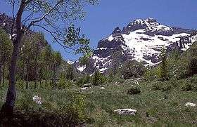
Mount Gilbert is the sixth-highest named mountain of the Ruby Mountains and the eighth-highest in Elko County, in Nevada, United States. It is the forty-third-highest mountain in the state.[3] The peak is a spectacular part of the view from State Route 227 in Lamoille Valley, rising over 5,300 feet (1,620 m) above the valley floor at Lamoille. It rises from the head of Seitz Canyon, and is part of the west wall of Right Fork Canyon (a branch of Lamoille Canyon). The summit is a high glacial horn, located about 22 miles (35 km) southeast of the community of Elko within the Ruby Mountains Ranger District of the Humboldt-Toiyabe National Forest.

References
- 1 2 "Mount Gilbert, Nevada". Peakbagger.com. Retrieved 2008-04-03.
- ↑ "Mount Gilbert". Geographic Names Information System. United States Geological Survey. Retrieved 2008-11-22.
- ↑ "Nevada 11,000-foot Peaks". Peakbagger.com. Retrieved 2014-10-22.
External links

This article is issued from
Wikipedia.
The text is licensed under Creative Commons - Attribution - Sharealike.
Additional terms may apply for the media files.