Mount Degenhardt
| Mount Degenhardt | |
|---|---|
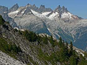 In background left to right, Mouth Terror, Mount Degenhardt, The Pyramid, Inspiration Peak and the McMillan Spires | |
| Highest point | |
| Elevation | 8,000+ ft (2,440+ m) [1] |
| Prominence | 280 ft (90 m) [1] |
| Coordinates | 48°46′17″N 121°17′35″W / 48.77139°N 121.29306°WCoordinates: 48°46′17″N 121°17′35″W / 48.77139°N 121.29306°W [2] |
| Geography | |
 Mount Degenhardt | |
| Parent range | Cascade Range |
| Topo map | USGS Mount Challenger |
Mount Degenhardt, elevation 8,000+ ft (2,440+ m), is a mountain peak in the Picket Range in the U.S. state of Washington and within North Cascades National Park.[3] Located in the northern section of the park, Mount Degenhardt is .30 mi (0.48 km) southeast of Mount Terror and .75 mi (1.21 km) west of McMillan Spire. Mount Degenhardt is named after William Degenhardt, an early 20th century mountain climber. The Terror Glacier lies on the southeast slopes of Mount Degenhardt.
References
- 1 2 "Mount Degenhardt, Washington". Peakbagger.com. Retrieved July 20, 2013.
- ↑ "Mount Degenhardt". Geographic Names Information System. United States Geological Survey. Retrieved July 20, 2013.
- ↑ Mount Challenger, WA (Map). TopoQwest (United States Geological Survey Maps). Retrieved July 20, 2013.
This article is issued from
Wikipedia.
The text is licensed under Creative Commons - Attribution - Sharealike.
Additional terms may apply for the media files.