Mount Andrus
| Mount Andrus | |
|---|---|
 Satellite view | |
| Highest point | |
| Elevation | 2,978 m (9,770 ft) |
| Coordinates | 75°48′0″S 132°18′0″W / 75.80000°S 132.30000°WCoordinates: 75°48′0″S 132°18′0″W / 75.80000°S 132.30000°W |
| Geography | |
 Mount Andrus | |
| Parent range | Ames Range |
| Geology | |
| Age of rock | Unknown |
| Mountain type | Shield volcano |
| Last eruption | Unknown |
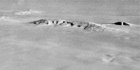
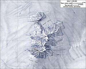
Mount Andrus is a shield volcano 3.2 km (2 mi) SE of Mount Boennighausen in the SE extremity of Ames Range, in Marie Byrd Land, Antarctica. Mapped by USGS from surveys and U.S. Navy air photos, 1964-68. Named by US-ACAN for Lt. Carl H. Andrus, US Navy, medical officer and Officer-in-Charge of Byrd Station in 1964.
Andrus has a 4.5 km-wide caldera at its summit. Weak fumarolic activity was detected in 1977 at Mt. Kaufmann in the northern end of the Ames Range of which Mt. Andrus is the southernmost volcano.
In an interesting side note, Mt. Andrus was reportedly climbed by one Michael J. Andrus (no relation to Carl H. Andrus) in August 2006 for the purpose of downhill skiing, which would make him the first Andrus to visit the mountain (though perhaps not the last). Carl H. Andrus is himself an avid mountain climber, having summited all 46 of the Adirondack high peaks and having, in his youth, climbed the Matterhorn.
See also
References
- "Andrus". Global Volcanism Program. Smithsonian Institution.
- LeMasurier, W. E.; Thomson, J. W. (eds.) (1990). Volcanoes of the Antarctic Plate and Southern Oceans. American Geophysical Union. p. 512 pp. ISBN 0-87590-172-7.
External links
- https://web.archive.org/web/20051030114935/http://usarc.usgs.gov/antarctic_atlas/
- http://www.skimountaineer.com/