Mount Agassiz (Utah)
| Mount Agassiz | |
|---|---|
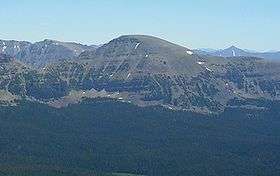 West side of Mt. Agassiz as seen from Bald Mountain | |
| Highest point | |
| Elevation | 12,433 ft (3,790 m) NAVD 88[1] |
| Prominence | 1,018 ft (310 m) [1] |
| Coordinates | 40°42′40″N 110°49′25″W / 40.7110572°N 110.823503°WCoordinates: 40°42′40″N 110°49′25″W / 40.7110572°N 110.823503°W [2] |
| Geography | |
 Mount Agassiz Location in Utah | |
| Location | Duchesne / Summit counties, Utah, U.S. |
| Parent range | Uinta Mountains |
| Topo map | USGS Hayden Peak |
Mount Agassiz is a peak in the Uinta Mountains of northeastern Utah with an elevation of 12,433 feet (3,790 m). It is located in the High Uintas Wilderness and the Uinta-Wasatch-Cache National Forest. The summit is named in honor of Louis Agassiz,[3] a well-known paleontologist, glaciologist and geologist.
References
- 1 2 "Mount Agassiz, Utah". Peakbagger.com. Retrieved 2009-01-24.
- ↑ "Mount Agassiz". Geographic Names Information System. United States Geological Survey. Retrieved 2009-01-24.
- ↑ "What Utah mountain range honors prominent geoscientists of the 19th century and who were they?". Utah Geological Survey. Utah Department of Natural Resource. Retrieved 2009-01-24.
External links

- "Mount Agassiz". SummitPost.org.
- Hayden Peak quadrangle, Utah (Map). 1:24000. 7.5 Minute Topographic. USGS.
This article is issued from
Wikipedia.
The text is licensed under Creative Commons - Attribution - Sharealike.
Additional terms may apply for the media files.