Measham
| Measham | |
|---|---|
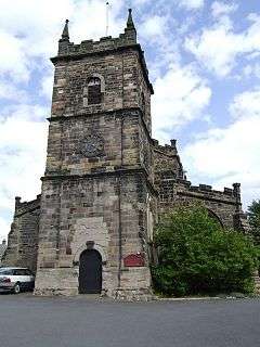 St Lawrence Church, Measham | |
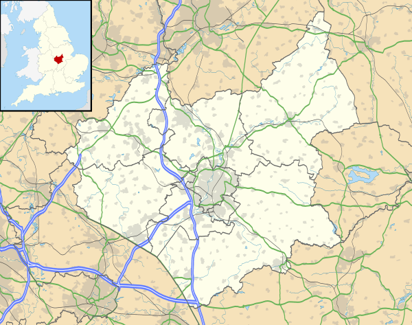 Measham Measham shown within Leicestershire | |
| Population | 5,209 [1] |
| OS grid reference | SK 33077 11844 |
| • London | 177 km |
| Civil parish |
|
| District | |
| Shire county | |
| Region | |
| Country | England |
| Sovereign state | United Kingdom |
| Post town | SWADLINCOTE |
| Postcode district | DE12 |
| Dialling code | 01530 |
| Police | Leicestershire |
| Fire | Leicestershire |
| Ambulance | East Midlands |
| EU Parliament | East Midlands |
| UK Parliament |
|
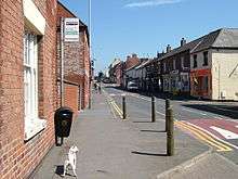
Measham is a large English village in Leicestershire close to the borders with Derbyshire, Staffordshire and Warwickshire. It lies just off the A42, 4.5 miles (7.25 km) south of Ashby-de-la-Zouch (the closest town), and within the National Forest.[2][3] Historically in Derbyshire, it was part of an enclave absorbed into Leicestershire in 1897 (see County Enclaves).[4][5] The name of the village is thought to mean homestead on the River Mease.[6].
History
Early history
The village name, Meas-Ham, suggests it was founded in the Saxon period between AD 350 and 1000.[7]
Domesday
Immediately before the Norman Conquest of 1066, the village belonged to "Earl Algar". In the Domesday Book of 1086, the village is recorded as belonging directly to the King, as part of a royal estate centred on Repton.[8][9] It was assessed as having a taxable value of 2 geld units (quite small), and containing land for 3 ploughs, 20 acres of meadow, and a square furlong of woodland (10 acres).[8]
12th–13th centuries
The manor passed from the crown to the Earls of Chester.[10] In 1235 it is recorded as being in the possession of Clementia (Clemence de Fougères), widow of Ranulf de Blondeville, 6th Earl of Chester.[10] Measham Museum states that the manor belonged to the De Measham family, which held it until 1308.[11] Given the ownership by the crown and then the Earls of Chester, neither actually resident, it appears the De Measham family held the manor as feudal tenants, rather than formal owners, probably in return for military service. (See the Feudalism in England)
14th–15th centuries
By the 13th century, the rights to the church appear to have passed to Repton Priory, as in 1272 King Henry III issued a charter confirming its possession of several church and chapelries, including that of Measham.[12]
The original chapel of ease dated from 1172, but the present St Laurence's Church was built in 1340, under the auspices of Repton Priory.[11]
On 24 March 1311, King Edward II granted two charters to William de Bereford, Lord of the Manor of Measham, to hold a market and a fair.[13] The charters allowed for a market on Tuesdays and for an annual three-day fair around the festival of the Translation of St Thomas the Martyr (7 July).[10][13] By 1817 both market and fair had died out.[10]
This medieval settlement is thought to have been mainly agricultural, but coal mining is known to have taken place as early as the 13th century, and William De Bereford died getting coal; records of his death show the village's coal resources to be worth 13s. 4d a year.[11]
In 1355, Edmund de Bereford, son of William, died leaving the manor of Measham to three heirs: Joan de Ellesfield, John de Maltravers and Margaret de Audley.[10]
During the 15th century, the manor came into the hands of Walter Blount, 1st Baron Mountjoy.[11]
In 1454, the manor was recorded as in the possession of Sir William Babington at the time of his death; and in 1474 it was in the possession of John Babington (presumably his son).[10]
16th–17th centuries
In 1596 Measham was dismissed by William Wyrley as "a village belonging to Lord Shefield, in which are many coal mines, [but] little else worthy of remembrance." It was omitted altogether from Richard Blome's gazetteer of market towns in 1673.
In 1563 the manor belonged to Walter Blount, 1st Baron Mountjoy. However, by 1616 it had passed to Sir Francis Anderson, only to return to the Sheffield family, as it was owned by Edmund Sheffield, 2nd Duke of Buckingham and Normanby in 1712.[10]
18th–19th centuries
The manor found its way to William Wollaston, who sold it to Joseph Wilkes in 1780 for £50,000; after whose death it was purchased by Reverend Thomas Fisher.[10][11] The actual manor house was demolished in the 1960s.[14]
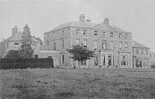
In 1767, William Abney Esq. built an alternative manor house at Measham-Field (North East of the village), which by 1817 had passed to his son, Edward Abney Esq.[10] This was what would become known as Measham Hall, a mid-Georgian seven-bay stately home. The site would, however, become used for coalmining. The Hall subsequently suffered from subsidence and was demolished by the National Coal Board in 1959.[14][15]
By the early 19th century, Measham church was still associated with Repton parish, as a "parochial chapelry".[10]
Industrial Revolution
Around the time of Joseph Wilkes, Measham went through a prosperous period associated with the Industrial revolution. This growth that lasted into the 20th century.[11] At the beginning of the 19th century, Ashby Canal was built through the village. The Ashby and Nuneaton Joint Railway followed, opening towards the end of the century. The village was also on the main road between Birmingham and Nottingham (later the A453). It became a hub of local industry, famous for its brickwork and Joseph Wilkes "Jumb Bricks" (made larger to avoid tax).[11] Other village industry included banking, breweries, coalmines and brick-making (with clay from local clay pits), a tramway, and boot, lace, cotton, carding and bleach mills.[11][14]
A market hall was said to have been built by Joseph Wilkes about the turn of the 19th century, but by 1817 the market had ceased to operate and the market-house was being converted into a dwelling.[10] This later became known as Cross House: 58 High Street; the area to the rear on Queen Street, now used as car parking, is the original market place.[14]
The village Baptist chapel was built in 1811, although Baptist ministers had been active in the village since the 1730s. A Temperance Hall built in 1852 now serves as the Age Concern building.[10]
In 1839 the village received an official visit from Queen Adelaide, who in her widowhood, frequently visited the area, staying at nearby Gopsall Park, home of her previous Lord Chamberlain, The Earl of Howe. Queen Street was named in her honour after her visit.[16]
By 1848 the population had swelled to 1615.[16] A further chapel was constructed for the Methodists, and a Catholic church was built, financed by a local lady aristocrat. (It was demolished in the last five years gave way to houses.
20th–21st centuries
Measham continued to grow residentially and industrially in the 20th and 21st centuries. Large-scale housing estates were built, including council and private housing, so that the population swelled to 4,849 in 2001. Development of the British Car Auctions site in the south-west of the village after World War Two prompted further industrial development in the area, which has grown into the Westminster Industrial Estate.[14]
The 20th century also brought periods of sharp decline. Passenger services on the Ashby and Nuneaton Joint Railway ceased in 1931.[17] Freight traffic continued until 1971, after which the line was dismantled.[17] The canal similarly closed in 1957. The traditional industries of the village began to die out, with the boot and shoe factory closing in the 1960s and Measham Colliery in 1986.[14] The 1960s saw many of the village's fine buildings demolished, including the Manor House, Measham Hall and the Vicarage.[14]
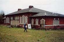
The village has in recent years seen further development. After many years of neglect and having fallen into disrepair, Measham's former railway station has been renovated to provide a new home for the Measham Museum. The former engine sheds have been developed into industrial workshops, and the former engine yards converted into a millennium garden and public green-space. A new library and a new leisure centre were also built in the last decade, and there are plans to resuscitate the Ashby Canal. Due to housing being constructed along the original route through Measham, the canal will follow the route of the old railway, with a wharf and adjacent visitors centre/shops/cafes planned for the village centre.
Notable residents
In birth order:
- Walter Blount, 1st Baron Mountjoy (c. 1416 – 1474), politician, acquired Measham Manor.
- Joseph Wilkes (1733–1805), industrialist and agricultural improver, bought Measham Manor in 1777 and instigated strong local development.
- Maria Jane Jewsbury (1800–1833), woman of letters, was born in Measham.
- Geraldine Jewsbury (1812–1880), novelist and sister of Maria Jane, was born in Measham.
- Charles Lloyd (1835–1908), pipe-organ builder, was born in Measham.
- Harry German (1865–1935), first-class cricketer (Leicestershire), was born in Measham.
- Sir Frank Watson Dyson (1868–1939), Astronomer Royal noted for work on solar eclipses, was born in Measham.
- John Compton (1876–1957), pipe-organ builder apprenticed to Charles Lloyd, was born in Newton Burgoland, near Measham.
- Arthur Samson (1898 – post-1922), professional footballer (goalkeeper, Birmingham City F. C., was born in Measham.
- Cyril Trigg (1917–1993), professional footballer (Birmingham City, etc.), was born in Measham.
- Steve Yates (born 1953), professional footballer (Southend United F. C.), was born in Measham and began his career with Measham Town F. C.
Measham teapots
Measham has a long tradition of pottery manufacture: the area is rich in clay and extraction is recorded as early as the 13th century.[18]
The famous Measham Ware, traditionally associated with the canals and narrow boats, was produced from the last quarter of the 19th century until around 1914 (other sources say 1910).[18] However, it was not actually produced in Measham, but in nearby villages: primarily Church Gresley.[18] It is thought to have acquired the epithet Measham as it was primarily sold by a Mrs Anne Bonas, from her shop on High Street, Measham.[19]
Measham Ware is earthenware; it has a dark brown Rockingham glaze with additions of white clay colourfully painted usually with flowers and a motto, often personalised.[20] Most commonly seen are the teapots, which often have a distinct miniature teapot as a finial on the cover.[21]
The earliest known production was in 1870 by William Mason of Church Gresley (later Mason Cash); the early price list refers to the pieces as Motto Ware, although it would later also be called Barge Ware due to its association with the canals.[21]
Measham Ware was popular with those on the canals. People passing through Measham on the Ashby Canal would place their order for their personalised teapot as they passed through the village, and collect it when they next travelled through.[22]
Measham Ware also found popularity among the farm labourers of Norfolk and Suffolk who, after collecting the harvest in their own counties, would often travel to Burton Upon Trent to work in the maltings and other industries associated with the breweries. Measham Ware became a popular gift to take home to loved ones.[22]
Local villagers often bought them as a wedding gift; passing them down from generation to generation at weddings.[22]
Production of Measham Ware ended around 1910–14, although modern reproductions have been produced in recent years.
The Measham Museum contains a large collection of Measham Ware, and the Victoria and Albert Museum in London also has an example on display.[18][20]

Industrialisation
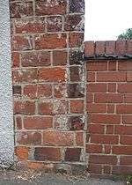
A figure prominent in the history of Measham was Joseph Wilkes, an entrepreneur during the early part of the industrial revolution. Wilkes bought Measham Manor from William Wollaston in 1777 and undertook extensive industrial and agricultural development, many signs of which are still visible today. He used larger bricks (twice the standard size) in much of his architecture to reduce the numbers used and thereby the amount of brick tax payable.[23]
Transport
The railway came to Measham in 1873 as the Ashby and Nuneaton Joint Railway: see Battlefield Line Railway (the last existing section of the ANJR). Leicestershire County Council has recently renovated the old station building as part of the Ashby Canal restoration; it currently serves as home to the Measham Museum.[24]
Minorca opencast
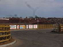
In 2011 UK Coal was given permission to develop an opencast coalmine on the site of the former Minorca colliery on the outskirts of Measham.[25] Measuring 1 mile (1.6 km) by .5 miles (0.80 km), the mine will yield 1,250,000 tonnes (1,380,000 tons) of coal over five years, and 250,000 tonnes (280,000 tons) of clay. The development has been opposed by some local residents, worried about environmental effects and vehicle noise.[25]
Sport
The local football team is called Measham Imperial, nicknamed "The Imps". It currently plays in the North Leicestershire Windmills League Division Three. Measham Welfare Football Club also fields a variety of teams and offers football to local children of ages 6–18, as well as boasting an adults first team and reserve team. The club is based out of Measham Leisure Centre.
Measham hosts the National Forest Taekwondo group, which started in 2013 and trains at the Church Hall. It welcomes all practitioners from the age of eight up. It covers training in all areas of this Olympic sport, from self-defence to the traditional patterns.
References
- William Wyrley cited in T. Bulmer’s History, Topography and Directory of Derbyshire (London, 1895 ed.)
- Nikolaus Pevsner, The Buildings of England: Leicestershire and Rutland , 1960 (first) edition.
Notes
- ↑ http://measham.leicestershireparishcouncils.org/census-2001.html
- ↑ OS Explorer Map 245: The National Forest : (1:25 000) : ISBN 0 319 24028 2
- ↑ Map Details retrieved 11 April 2013
- ↑ "Derbyshire Enclaves Map". Retrieved 22 April 2013.
- ↑ http://freepages.genealogy.rootsweb.ancestry.com/~brett/seal/seal.htm
- ↑ Watts, Victor et al., (2004) The Cambridge Dictionary of Place Names, Cambridge University Press, Cambridge. ISBN 0-521-36209-1
- ↑ "Origins of Place Names". Domesday Book Online. Retrieved 22 April 2013.
- 1 2 "Measham". Domesday Map. Archived from the original on 5 May 2013. Retrieved 22 April 2013.
- ↑ http://www.applebymagna.org.uk/appleby_history/in_focus5_plannedvillage.htm
- 1 2 3 4 5 6 7 8 9 10 11 12 Magna Britannia: volume 5: Derbyshire: 'Parishes: Packington - Repton'. 1817. pp. 228–246.
- 1 2 3 4 5 6 7 8 "Measham Museum". Retrieved 22 April 2013.
- ↑ A History of the County of Derby: Volume 2: 'Houses of Austin canons: The priory of Repton, with the cell of Calke',. 1907. pp. 58–63.
- 1 2 "GAZETTEER OF MARKETS AND FAIRS IN ENGLAND AND WALES TO 1516: PLACES". Retrieved 22 April 2013.
- 1 2 3 4 5 6 7 "MEASHAM CONSERVATION AREA APPRAISAL AND STUDY" (PDF). Retrieved 23 April 2013.
- ↑ "Measham Hall". Lost Heritage. Archived from the original on 23 October 2013.
- 1 2 'Mayland - Melbourn', A Topographical Dictionary of England. 1848. pp. 280–283.
- 1 2 Speller, John. "Ashby & Nuneaton Joint Railway (L&NWR/MR)". John Speller's Web Pages. Retrieved 16 January 2012.
- 1 2 3 4 "The Measham Teapot". Measham Museum and History Group. Retrieved 24 April 2013.
- ↑ "Measham Ware". Landshapes: The National Forest - Heritage in the Making. Retrieved 24 April 2013.
- 1 2 "Measham Ware". V&A Museum. Retrieved 24 April 2013.
- 1 2 "Barge Ware". Judith Harvey Antiques. Archived from the original on 23 September 2013. Retrieved 24 April 2013.
- 1 2 3 "Measham Ware Teapots". BBC: A History of the World. Retrieved 24 April 2013.
- ↑ Joseph Wilkes online biography
- ↑ "Archived copy". Archived from the original on 13 July 2011. Retrieved 3 February 2011.
- 1 2 Leicestershire opencast coal mine gains approval
External links
| Wikimedia Commons has media related to Measham. |
- Measham Parish Council
- Map sources for Measham
Towns and villages of North West Leicestershire | ||
|---|---|---|
| Towns | 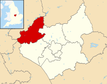 | |
| Large villages | ||
| Small villages |
| |
| Hamlets | ||