Moszczanka, Opole Voivodeship
| Moszczanka | |
|---|---|
| Village | |
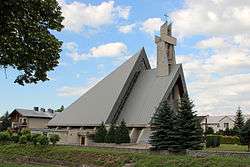 Church in Moszczanka | |
 Moszczanka | |
| Coordinates: 50°18′3″N 17°29′28″E / 50.30083°N 17.49111°E | |
| Country |
|
| Voivodeship | Opole |
| County | Prudnik |
| Gmina | Prudnik |
| Highest elevation | 350 m (1,150 ft) |
| Lowest elevation | 290 m (950 ft) |
| Population | 1,116 |
Moszczanka [mɔʂˈt͡ʂanka] (German: Langenbrück) is a village in the administrative district of Gmina Prudnik, within Prudnik County, Opole Voivodeship, in south-western Poland, close to the Czech border.[1] It lies approximately 7 kilometres (4 mi) west of Prudnik and 52 km (32 mi) south-west of the regional capital Opole.
Before 1945 the area was part of Germany (see Territorial changes of Poland after World War II).
The village has a population of 1,116.
References
| Town and seat |  | |
|---|---|---|
| Villages | ||
This article is issued from
Wikipedia.
The text is licensed under Creative Commons - Attribution - Sharealike.
Additional terms may apply for the media files.