Moses Coulee

Moses Coulee is a canyon in the Waterville plateau region of Douglas County, Washington. Moses Coulee is the second-largest and westernmost canyon of the Channeled Scablands, located about 30 kilometres (19 mi) to the west of the larger Grand Coulee. This water channel is now dry, but during glacial periods, large outburst floods with discharges greater than 600,000 m3/s (21,000,000 cu ft/s) carved the channel.[1] Some researchers propose that floods from glacial Lake Missoula formed Moses Coulee,[2] while others suggest that subglacial floods from the Okanogan Lobe incised the canyon.[3]
The mouth of Moses Coulee discharges into the Columbia River at the Great Gravel Bar of Moses Coulee, a National Natural Landmark, one of the largest examples of bars created by the Channeled Scablands outburst floods.
Geologic history

Geological setting
Moses Coulee cuts into the Waterville Plateau, which lies in the northwest corner of the Columbia River Plateau. The plateau is part of the Columbia River Basalt Group, a large igneous province that lies across parts of the states of Washington, Oregon, and Idaho in the United States of America. During late Miocene and early Pliocene times, one of the largest flood basalts ever to appear on the earth's surface engulfed about 163,700 km² (63,000 mile²) of the Pacific Northwest, forming a large igneous province with an estimated volume of 174,300 km³. Eruptions were most vigorous from 17—14 million years ago, when over 99% of the basalt was released. Less extensive eruptions continued from 14—6 million years ago. These lava flows have been extensively exposed by the erosion resulting from the Missoula Floods, which laid bare many layers of the basalt flows on the edges of the plateau along the course of Moses Coulee.[4][5][6][7][8]
The glacial history
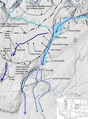
Pleistocene glaciers advanced onto the Waterville Plateau, with the Okanogan Lobe of the Cordilleran Ice Sheet reaching as far south as the town of Withrow. Evidence for glaciation on the Waterville Plateau includes polished and striated bedrock, glacial erratics, drumlinoid topography, eskers, moraines, meltwater channels, and glacial till. The Withrow Moraine complex marks the maximum southern extent of the Okanogan Lobe, and a series of recessional moraine complexes represent retreating ice margins. Ice damming of the Columbia River formed Glacial Lake Columbia and Lake Spokane, larger lakes than Lake Roosevelt, which is currently backed up in the same location behind the Grand Coulee Dam. [4][5][9][10]
Creation of Moses Coulee

A precursor to glacial-flood-cut Moses Coulee existed prior to the glacial floods as a drainage basin with a number of side streams, draining the southern portion of the plateau. These streams had combined into a canyon that drained to the Columbia near the current mouth of Moses Coulee. These side drainages are still visible today along the coulee walls as truncated streambeds, interspersed with gable-like highlands.[11]
The Okanogan lobe of the Cordilleran Glacier moved down the Okanogan River valley, covering 500 mi² of the Waterville Plateau and blocked the ancient route of the Columbia River, backing up water to create Glacial Lake Columbia and Lake Spokane. Initially water discharged from Lake Columbia by running up through the head of Grand Coulee and down through Foster Coulee to rejoin the Columbia River. As the glacier moved further south, Foster Coulee was cut off and the Columbia River then discharged through Moses Coulee, which runs southward slightly to the east of the ancient and current course of the Columbia. As the Okanogan lobe grew, it blocked Moses Coulee as well; the Columbia found the next lowest route through the region which was eroded to become the modern Grand Coulee. Flowing across the current Grand Coulee and Dry Falls regions, the ice age Columbia then entered the Quincy Basin and joined Crab Creek, following Crab Creek’s course southward past the Frenchman Hills and turning west to run along the north face of the Saddle Mountains and rejoin the previous and modern course of the Columbia River just above the main water gap in the Saddle Mountains, Sentinel Gap.
Although the Columbia River flowed only for a short period through Moses Coulee, this period included one or more of the tremendous flows from the Missoula Floods.[10]
After the glacier
As the Okanogan lobe melted, the upper portions of Moses Coulee were littered with clear evidence of its passing in the Withrow Moraine. The glacier left behind a blanket of glacial till, up to 50 feet (15 m) thick in places. This glacial till, made up of clay, silt, sand, gravel, cobblestones, and erratic boulders, covers most of the upper coulee.[11]
Today Moses Coulee supports an excellent example of a shrub-steppe ecoregion. Vegetation includes sagebrush, rabbitbrush, greasewood, hopsage, bitterbrush, bunchgrass, buckwheat and other vegetation once common to most of the Columbia Plateau.[11]
Moses Coulee Preserve
The Nature Conservancy has established the Moses Coulee Preserve, which is a 3,588-acre (14.52 km2) contiguous, intact shrub-steppe habitat. It is located 2 miles (3.2 km) south of Jameson Lake near the head of Moses Coulee. It provide habitat for a rich variety of birds (lazuli bunting, common goldeneye, sage thrasher, sage sparrow, poorwill, mountain bluebird, loggerhead shrike, canyon wren, white-throated swift, golden eagle), plants (sagebrush buttercup, shooting star, sulphur lupine, serviceberry, mock orange, slender cryptantha, Tiehm's rush, big sagebrush, bluebunch wheatgrass and sego lily) and animals (mule deer, least chipmunk, bats, and marmot).[12]
References
- ↑ Larsen, Isaac J.; Lamb, Michael P. (October 2016). "Progressive incision of the Channeled Scablands by outburst floods". Nature. 538 (7624): 229–232. doi:10.1038/nature19817. ISSN 0028-0836.
- ↑ "Megafloods and Clovis cache at Wenatchee, Washington". Quaternary Research. 85 (3): 430–444. 2016-05-01. doi:10.1016/j.yqres.2016.02.007. ISSN 0033-5894.
- ↑ "Regional reconstruction of subglacial hydrology and glaciodynamic behaviour along the southern margin of the Cordilleran Ice Sheet in British Columbia, Canada and northern Washington State, USA". Quaternary Science Reviews. 28 (23–24): 2420–2444. 2009-11-01. doi:10.1016/j.quascirev.2009.04.019. ISSN 0277-3791.
- 1 2 Alt, David. Glacial Lake Missoula & its Humongous Floods. Mountain Press Publishing Company. ISBN 978-0-87842-415-3.
- 1 2 Bjornstad, Bruce (2006). On the Trail of the Ice Age Floods: A Geological Guide to the Mid-Columbia Basin. Keokee Books; Sand Point, Idaho. ISBN 978-1-879628-27-4.
- ↑ Portions of this article, including a figure, are adapted from works of the United States Government, which are in the public domain
- ↑ Alt, David & Hyndman, Donald (1995). Northwest Exposures: a Geologic Story of the Northwest. Mountain Press Publishing Company. ISBN 978-0-87842-323-1.
- ↑ Carson, Robert J.; Pogue, Kevin R. (1996). Flood Basalts and Glacier Floods:Roadside Geology of Parts of Walla Walla, Franklin, and Columbia Counties, Washington. Washington State Department of Natural Resources (Washington Division of Geology and Earth Resources Information Circular 90). ISBN none.
- ↑ USGS Site
- 1 2 Mueller, Marge & Ted (1997). Fire, Faults and Floods. University of Idaho Press, Moscow, Idaho. ISBN 978-0-89301-206-9.
- 1 2 3 Washington history link.
- ↑ Nature Conservancy site
External links
| Wikimedia Commons has media related to Moses Coulee. |
- University of Wisconsin Green Bay geological site addressing Moses Coulee
- Moses Coulee & Beezley Hills: A Signature Western Landscape
Coordinates: 47°27′30″N 119°48′00″W / 47.45833°N 119.80000°W
| Ice Age Glacial Floods | 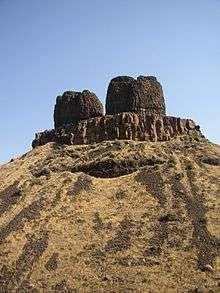 | |
|---|---|---|
| Glacial Lakes | ||
| Temporary Lakes | ||
| Ice Age Floods Glacial Residue | ||
| Ice Age Floods Erosion & Deposition Features | ||
| Related contemporaneous events | ||