Morral de Cabrafeixet
| Morral de Cabrafeixet | |
|---|---|
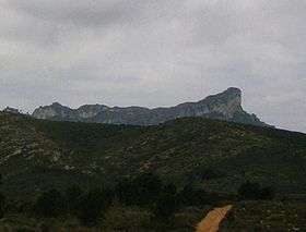 Morral de Cabrafeixet seen from the northeast | |
| Highest point | |
| Elevation | 753.5 m (2,472 ft) |
| Coordinates | 40°53′47.4″N 00°37′16.4″E / 40.896500°N 0.621222°ECoordinates: 40°53′47.4″N 00°37′16.4″E / 40.896500°N 0.621222°E |
| Geography | |
 Morral de Cabrafeixet Catalonia, Spain | |
| Location |
El Perelló (Baix Ebre), Catalonia |
| Parent range | "Les Moles", wider Serra del Boix range |
| Geology | |
| Mountain type | Calcareous |
| Climbing | |
| First ascent | Unknown |
| Easiest route | From El Perelló |
Morral de Cabrafeixet is one of the highest mountains of the Cardó Massif, Catalan Pre-Coastal Range, Catalonia, Spain. Its NW side has an impressive escarpment visible from Highway N-340 approaching El Perelló from the north. This mountain has an elevation of 753 metres above sea level.[1]
Balma de Cabrafeixet is a prehistoric site with cave paintings located right below the Morral de Cabrafeixet escarpment. The entrance to the cave has been closed with an iron bar door to prevent vandalism.[2] Wild flowers and butterflies are abundant in this lonely, uninhabited area.
Getting there
One should take the road from El Perelló to Rasquera. After 7 km turn left at a sign saying Pintures rupestres. Take right after 2 km (unpaved road). At the T-junction, the road to the left leads to the Cabrafeixet cave and to a kind of cirque with an impressive sight of Buinaca. The road to the right leads up to the base of the Cabrafeixet escarpment and further on to breathtaking sights of other jagged peaks and valleys.
See also
References
- ↑ "Mapa Topogràfic de Catalunya". Institut Cartogràfic de Catalunya. Retrieved May 22, 2010. .
- ↑ enciclopèdia.cat - Morral de Cabrafeixet
External links