Morishita Station (Tokyo)
S11 E13 Morishita Station 森下駅 | |
|---|---|
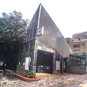 A5 entrance to Morishita Station, 2017 | |
| Location |
Morishita 1-13-10 (Shinjuku Line) Morishita 2-17-17 (Oedo Line) Kōtō, Tokyo (東京都江東区森下1-13-10 (Shinjuku Line) 東京都江東区森下2-17-17 (Ōedo Line)) Japan |
| Operated by | Tokyo Metropolitan Bureau of Transportation (Toei) |
| Line(s) | |
| Other information | |
| Station code |
S-11 (Shinjuku Line) E-13 (Ōedo Line) |
| History | |
| Opened | 1978 |
| Traffic | |
| Passengers ([1][2]) | 121,571 daily |
Morishita Station (森下駅 Morishita-eki) is a subway station in Kōtō, Tokyo, Japan, operated by Toei Subway. Its station numbers are S-11 (Shinjuku Line) and E-13 (Ōedo Line).
Lines
Morishita Station is served by the following two lines.
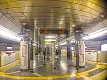
Platforms
Morishita Station consists of two island platforms (one for each line), each served by two tracks.
| 1 | ○ Toei Shinjuku Line | for Bakuro-yokoyama, Shinjuku, Sasazuka, Hashimoto |
| 2 | ○ Toei Shinjuku Line | for Motoyawata |
| 3 | ○ Toei Ōedo Line | for Ryogoku, Iidabashi |
| 4 | ○ Toei Ōedo Line | for Daimon, Roppongi |
History
The station opened on December 21, 1978; service on the Ōedo Line began on December 12, 2000.
Surrounding area
The station is located underneath the intersection of Tokyo Metropolitan Routes 50 (Shin-Ōhashi-dōri) and 463 (Kiyosumi-dōri). The area is typically shitamachi, with a mix of mid-rise office buildings, apartment buildings, and homes. Being close to Ryōgoku, many sumōbeya are located in the vicinity.
Connecting bus service
Toei Bus: Morishita-Ekimae
- Mon 33: for Kameido Station
- Kyūkō 06: for National Museum of Emerging Science and Innovation
- Kin 11: for Kinshichō Station, Shinozaki Station
Adjacent stations
| « | Service | » | ||
|---|---|---|---|---|
| Toei Shinjuku Line S11 | ||||
| Bakuro-yokoyama S09 | Express | Ojima S15 | ||
| Hamacho S10 | Local | Kikukawa S12 | ||
| Toei Oedo Line E13 | ||||
| Ryogoku E12 | - | Kiyosumi-shirakawa E14 | ||
References
- ↑ "Morishita Station information" (in Japanese). Tokyo Metropolitan Bureau of Transportation. Archived from the original on 2006-10-08. Retrieved February 2010. Check date values in:
|accessdate=(help) - ↑ "Morishita Station information" (in Japanese). Tokyo Metropolitan Bureau of Transportation. Archived from the original on 2006-10-08. Retrieved February 2010. Check date values in:
|accessdate=(help)
External links
| Wikimedia Commons has media related to Morishita Station (Tokyo). |
- Tokyo Metropolitan Bureau of Transportation: Morishita Station (Shinjuku Line) (in Japanese)
- Tokyo Metropolitan Bureau of Transportation: Morishita Station (Ōedo Line) (in Japanese)
Coordinates: 35°41′17″N 139°47′54″E / 35.688007°N 139.798235°E