Moreton Valence
Moreton Valence is a village 6 miles south-west of Gloucester, Gloucestershire, England on the A38. It lies on the river Severn and the Gloucester and Sharpness Canal. The Parkend Canal bridge is located in the middle of Moreton Valence,[1] with the Parkend Bridge House which is a Grade II listed building.[2] The population of the village is 151 (2011).[3]
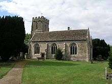
There is a church in the village called St Stephen's which is a Grade I listed building.[4] There are also several Grade II listed buildings within the village including Barracks Farmhouse, Mansfield House and Oakey Farmhouse.[5]
Most of the houses in Moreton Valence are built using Cotswold Limestone.[6]
History
The RAF Moreton Valence base was located here in November 1939, but was closed in July 1962.[7] The airfield was located to the East of the main village between the A38 and B4008. The base was mainly used during World War 2,[8] when the Gloster Aircraft Company were located here.[9] Several other RAF buildings were present in the area during the Second World War, including a storage depot which was present between 1944 - 1947,[10] and a Military Camp [11]
References
- ↑ "Gloucester & Sharpness Canal Bridges". Gloucester and Sharpness Canal. Retrieved 7 August 2016.
- ↑ "Parkend Bridge House". British Listed Buildings. Retrieved 7 August 2016.
- ↑ "Population of Moreton Valence". neighbourhood statistics. Retrieved 7 August 2016.
- ↑ "St Stephen Church". britishlistedbuildings. Retrieved 7 August 2016.
- ↑ "Grade II listed buildings". britishlistedbuildings. Retrieved 7 August 2016.
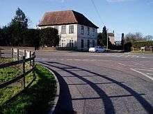
- ↑ "House on the A38 at Moreton Valence". Geograph. Retrieved 7 August 2016.
- ↑ "RAF Moreton Valence". Control Towers. Retrieved 7 August 2016.
- ↑ "Moreton Valence airfield history". Pastscape. Retrieved 7 August 2016.
- ↑ "Morton Valence Airfield Units". Airfields of Britain. Retrieved 7 August 2016.
- ↑ "MONUMENT NO. 1583034". Pastscape. Retrieved 7 August 2016.
- ↑ "MONUMENT NO. 1583710". Pastscape. Retrieved 7 August 2016.
| Wikimedia Commons has media related to Moreton Valence. |