Moraleda Channel

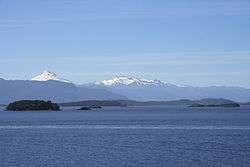
Canal Moraleda with Cerro Macá in the distance.
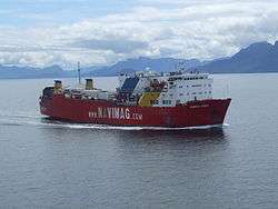
A ferry with occasional whale watching in the Canal Moraleda.
Moraleda Channel (Spanish: Canal Moraleda) is a body of water separating the Chonos Archipelago from the mainland of Chile. It is located at 44°24′53″S 73°25′14″W / 44.4147222°S 73.4205556°W, leading to Gulf of Corcovado. Southward from the mouth of the Aisén Fjord, Moraleda Channel divides into two arms. The east arm, called Canal Costa (Costa Channel), is the main one. Farther south the name changes to Estero Elefantes (Elefantes Estuary), which terminates in the gulf of the same name. The channel runs along the Liquiñe-Ofqui Fault.
The deepest part of the channel are situated in front of Magdalena Island.[1]
References
- ↑ Rodrigo, Cristián (2006). "Topografía submarina en canales de la Patagonia Norte" (PDF). Avances en el conocimiento oceanográfico de las aguas interiores chilenas, Puerto Montt a cabo de Hornos: 19–23. Retrieved 26 April 2013.
External links
- Chilean Navy, "General piloting regulations and information", STRAIT OF MAGELLAN, CHILEAN CHANNELS AND FIORDS Regulations and information for PILOTING. ROUTES (in Spanish), http://www.web.directemar.cl/, archived from the original on 8 October 2012, retrieved 16 April 2013 External link in
|publisher=(help) - Chilean Navy, "Sailing along the Strait of Magellan or Drake Passage", STRAIT OF MAGELLAN, CHILEAN CHANNELS AND FIORDS Regulations and information for PILOTING. ROUTES (in Spanish), http://www.web.directemar.cl/, archived from the original on 24 November 2012, retrieved 16 April 2013 External link in
|publisher=(help) - Chilean Navy, "Sailing throughout Chilean Straits, Channels and Fjords", STRAIT OF MAGELLAN, CHILEAN CHANNELS AND FIORDS Regulations and information for PILOTING. ROUTES (in Spanish), http://www.web.directemar.cl/, archived from the original on 26 November 2012, retrieved 16 April 2013 External link in
|publisher=(help) - Ministerio de Obras Públicas de Chile (2012), "Maps of all regions of Chile", Cartas camineras 2010 in 200 dpi and 70 dpi resolution available (jpg and pdf)
|format=requires|url=(help) (Maps) (in Spanish), Government of Chile, archived from the original on 4 September 2012, retrieved 20 April 2013
This article is issued from
Wikipedia.
The text is licensed under Creative Commons - Attribution - Sharealike.
Additional terms may apply for the media files.