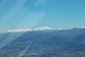
Monti Sabini
| Aurunci Mountains | |
|---|---|
|
Monti Aurunci | |
 Location of the range in Italy
| |
| Highest point | |
| Peak | Monte Tancia |
| Elevation | 1,292 m (4,239 ft) |
| Naming | |
| Etymology | Ancient tribal name |
| Geography | |
| Country | Italy |
| State/Province | Lazio |
| District | Rome, Rieti |
| Parent range | Apennine Mountains |
| Borders on | Tiber, Nera, Velino, Turano, Aniene. |
The Monti Sabini are mountain range in the Apennines of Latium, central Italy.
They area loacted in north-south direction between the Monti Reatini at east and the Tiber valley westwards. The upper section are the Monti Sabini proper, on the boundary between Latium and Umbria, and the Monti Lucretili sub-range, on the boundary between the province of Rieta and the Metropolitan City of Rome. The two sub-ranges are separated by the plain and hilly areas of the Sabina.
| Provinces and places | 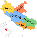 | |
|---|---|---|
| History |
| |
| Lakes | ||
| Mountains |
| |
| Geography | ||
| Politics | ||
Categories | ||
This article is issued from
Wikipedia.
The text is licensed under Creative Commons - Attribution - Sharealike.
Additional terms may apply for the media files.