Montgirod
| Montgirod | |
|---|---|
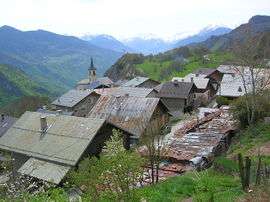 A view across the rooftops to the church | |
 Montgirod Location within Auvergne-Rhône-Alpes region  Montgirod | |
| Coordinates: 45°32′00″N 6°35′00″E / 45.5333°N 6.5833°ECoordinates: 45°32′00″N 6°35′00″E / 45.5333°N 6.5833°E | |
| Country | France |
| Region | Auvergne-Rhône-Alpes |
| Department | Savoie |
| Arrondissement | Albertville |
| Canton | Bourg-Saint-Maurice |
| Government | |
| • Mayor (2008–2014) | Rose Paviet |
| Area1 | 13.62 km2 (5.26 sq mi) |
| Population (2006)2 | 432 |
| • Density | 32/km2 (82/sq mi) |
| Time zone | UTC+1 (CET) |
| • Summer (DST) | UTC+2 (CEST) |
| INSEE/Postal code | 73169 /73210 |
| Elevation | 556–2,255 m (1,824–7,398 ft) |
| Website | www.mairie-montgirod-centron.fr |
|
1 French Land Register data, which excludes lakes, ponds, glaciers > 1 km2 (0.386 sq mi or 247 acres) and river estuaries. 2 Population without double counting: residents of multiple communes (e.g., students and military personnel) only counted once. | |
Montgirod is a former commune in the Savoie department in the Auvergne-Rhône-Alpes region in south-eastern France. On 1 January 2016, it was merged into the new commune of Aime-la-Plagne.[1]
See also
References
- ↑ Arrêté préfectoral 17 November 2015
External links
| Wikimedia Commons has media related to Montgirod. |
This article is issued from
Wikipedia.
The text is licensed under Creative Commons - Attribution - Sharealike.
Additional terms may apply for the media files.