Monterey Bay Academy Airport
| Monterey Bay Academy Airport | |||||||||||
|---|---|---|---|---|---|---|---|---|---|---|---|
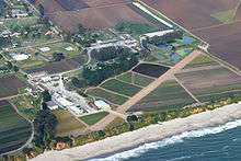 Monterey Bay Academy Airport, prior to its conversion to a grass runway. | |||||||||||
| Summary | |||||||||||
| Airport type | Public | ||||||||||
| Operator | Seventh-day Adventist Church | ||||||||||
| Location | Monterey Bay Academy | ||||||||||
| Elevation AMSL | 70 ft / 21 m | ||||||||||
| Coordinates | 36°54′22″N 121°50′35″W / 36.90611°N 121.84306°WCoordinates: 36°54′22″N 121°50′35″W / 36.90611°N 121.84306°W | ||||||||||
| Runways | |||||||||||
| |||||||||||
Monterey Bay Academy Airport (FAA LID: CA66) is a small daytime only airfield located near the city of Watsonville in Santa Cruz County, California, USA. This former strictly private use airport (now open to the public), is owned by the Seventh-day Adventist Church and is located on the campus of Monterey Bay Academy, previously the military installation Camp McQuaide. Since May 2013[1] the airstrip is operated by Ocean Shore Aviation, LLC,[2] a volunteer aviation group. The group restored the worn out dirt strip, converting it from dirt into a grass runway. In addition to fixing the runway, the group has secured a parking/tie-down area (paved with concrete), and has added a picnic area situated within walking distance to the parking/tie-down area overlooking the Pacific Ocean. A webcam is in operation and shows the tie down area.
History
In the 1940s, a small aircraft landing strip was built at Camp McQuaide so airplanes could drop targets into the ocean. After the end of the war, in 1948, it was converted to the private boarding school Monterey Bay Academy.[3]
Between 1980 and 1984 the airport was home to Pterodactyl Limited, a company that manufactured ultralight aircraft.[4]
See also
References
- ↑ https://www.youtube.com/watch?v=mHx1r0IAeFU
- ↑ http://www.oceanshoreaviation.com
- ↑ "Monterey Bay Academy Beginnings". MBA web site. Retrieved May 27, 2010.
- ↑ Adam Hunt. "Pterodactyl History". Archived from the original on April 26, 2010. Retrieved May 27, 2010.
External links
- "El Salto Resort, Camp McQuaide, & the Capitola Airport -1934". photo page of Capitola Museum web site. Archived from the original on September 24, 2010. Retrieved May 27, 2010.
- Paul Freeman (2009). "Santa Cruz - Capitola Airport, Santa Cruz, CA". Abandoned & Little-Known Airfields: California: Monterey area. Archived from the original on January 4, 2010. Retrieved May 27, 2010.
- Resources for this airport:
- FAA airport information for CA66
- AirNav airport information for CA66
- FlightAware airport information and live flight tracker
- SkyVector aeronautical chart for CA66