Monte Piana
| Monte Piana | |
|---|---|
 Southern Flank of Monte Piana | |
| Highest point | |
| Elevation | 2,324 m (7,625 ft) |
| Prominence | 440 metres (1,440 ft) |
| Coordinates | 46°36′55″N 12°14′45″E / 46.61528°N 12.24583°ECoordinates: 46°36′55″N 12°14′45″E / 46.61528°N 12.24583°E |
| Geography | |
 Monte Piana Location in the Alps | |
| Location | South Tyrol and Province of Belluno, Italy |
| Parent range | Dolomites |
The Monte Piana is a 2,324 meter tall mountain in the Sexten Dolomites and located on the border between the provinces of South Tyrol and Belluno. The smaller Northern summit of the mountain is named Monte Piano (2,305m).
During World War I the mountain was hotly contested between the Austrian and Italian Armies. The Austrians had occupied the Northern summit Monte Piano, while the Southern summit Monte Piana was in Italian hands. Today many remnants of the fierce fighting can still be found on both summits.
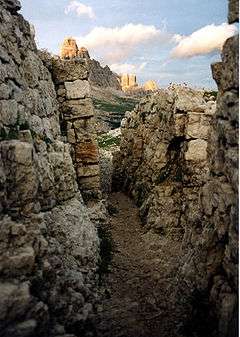 Italian World War I trenches on Monte Piana; view towards the Tre Cime di Lavaredo
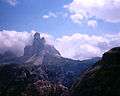 View of the Tre Cime di Lavaredo from Mount Piana.
External links
| Wikimedia Commons has media related to Monte Piana. |
- http://www.worldwarone.it/2015/06/first-world-war-one-day-itineraries.html
- Photos Monte Piana: und
- Monte Piana on www.cimeetrincee.it (Italian)
- Monte Piana on Fronte Dolomitico (Italian)
- www.montepiana.com Maps of the summit area (Italian)
This article is issued from
Wikipedia.
The text is licensed under Creative Commons - Attribution - Sharealike.
Additional terms may apply for the media files.