Monte Penice
| Monte Penice | |
|---|---|
 | |
| Highest point | |
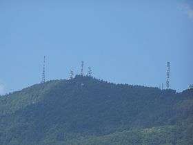
| Elevation | 1,460 m (4,790 ft) [1] |
| Coordinates | 44°47′04″N 9°19′01″E / 44.78444°N 9.31694°ECoordinates: 44°47′04″N 9°19′01″E / 44.78444°N 9.31694°E |
| Geography | |
 Monte Penice Location in Italy | |
| Location | Lombardy / Emilia-Romagna, Italy |
| Parent range | Apennines |
Monte Penice is a mountain of Lombardy and Emilia-Romagna in Italy. It has an elevation of 1,460 metres (4,790 ft) above sea level and belongs to the Ligurian Apennines.
References
- ↑ Monte Penice, turismo.provincia.pc.it
This article is issued from
Wikipedia.
The text is licensed under Creative Commons - Attribution - Sharealike.
Additional terms may apply for the media files.