Monte Lema
| Monte Lema | |
|---|---|
 | |
| Highest point | |
| Elevation | 1,621 m (5,318 ft) |
| Prominence | 140 m (460 ft) [1] |
| Isolation | 0.95 kilometres (0.59 mi) |
| Parent peak | Monte Tamaro |
| Coordinates | 46°2′24.2″N 8°49′54.4″E / 46.040056°N 8.831778°ECoordinates: 46°2′24.2″N 8°49′54.4″E / 46.040056°N 8.831778°E |
| Geography | |
 Monte Lema Location in the Alps | |
| Location |
Ticino, Switzerland Lombardy, Italy |
| Parent range | Lugano Prealps |
| Climbing | |
| Easiest route | Aerial tramway |
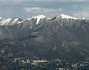
Monte Lema (1,621 m) is a mountain of the Lugano Prealps, located on the border between Switzerland and Italy. Its summit can easily reached by cable car from the village of Miglieglia (Ticino).
SOIUSA classification
According to the SOIUSA (International Standardized Mountain Subdivision of the Alps) the mountain can be classified in the following way:[2]
- main part = Western Alps
- major sector = North Western Alps
- section = Lugano Prealps
- subsection = Prealpi Varesine
- supergroup = Catena Tamaro-Gambarogno-Lema
- group = Gruppo del Tamaro
- subgroup = Gruppo del Lema
- code = I/B-11.II-A.1.c
See also
Notes
External links
| Wikimedia Commons has media related to Monte Lema. |
This article is issued from
Wikipedia.
The text is licensed under Creative Commons - Attribution - Sharealike.
Additional terms may apply for the media files.