Mont Avic
| Mont Avic | |
|---|---|
 | |
| Highest point | |
| Elevation | 3,006 m (9,862 ft) |
| Listing | Alpine mountains above 3000 m |
| Coordinates | 45°41′24″N 7°33′50″E / 45.69000°N 7.56389°ECoordinates: 45°41′24″N 7°33′50″E / 45.69000°N 7.56389°E |
| Geography | |
 Mont Avic Location in the Alps | |
| Location | Aosta Valley, Italy |
| Parent range | Graian Alps |
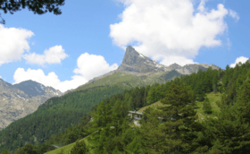
Mont Avic is a mountain in the Graian Alps, in the Aosta Valley, north-western Italy. It has an elevation of 3,006 m. It is included in the Gran Paradiso massif.
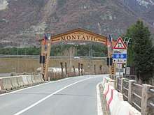
Entrance of the Parco Naturale del Mont Avic.
The peak is located on the boundary between the comuni of Champdepraz and Chambave, and gives its name to a regional natural park called Mont Avic Natural Park Parco Naturale del Mont Avic (It) / Parc Naturel du Mont-Avic (Fr) .
Mont Avic was ascended for the first time in 1875. The easiest route starts from Champdepraz valley; at first it follows well marked footpaths and then becomes steeper and more difficult.
Notes
This article is issued from
Wikipedia.
The text is licensed under Creative Commons - Attribution - Sharealike.
Additional terms may apply for the media files.