Mont-Tremblant
| Mont-Tremblant | |
|---|---|
| City | |
| Mont-Tremblant | |
 | |
| Nickname(s): Tremblant | |
 Location within Les Laurentides RCM | |
 Mont-Tremblant Location in central Quebec | |
| Coordinates: 46°07′N 74°36′W / 46.117°N 74.600°WCoordinates: 46°07′N 74°36′W / 46.117°N 74.600°W[1] | |
| Country |
|
| Province |
|
| Region | Laurentides |
| RCM | Les Laurentides |
| Constituted | November 22, 2000 |
| Government[2] | |
| • Federal riding | Laurentides—Labelle |
| • Prov. riding | Labelle |
| Area[2][3] | |
| • Total | 248.10 km2 (95.79 sq mi) |
| • Land | 234.40 km2 (90.50 sq mi) |
| Population (2011)[3] | |
| • Total | 9,494 |
| • Density | 40.5/km2 (105/sq mi) |
| • Pop 2006-2011 |
|
| • Dwellings | 7,492 |
| Time zone | UTC−5 (EST) |
| • Summer (DST) | UTC−4 (EDT) |
| Postal code(s) | J8E |
| Area code(s) | 819 |
| Highways |
|
| Website |
www.villede mont-tremblant.qc.ca |
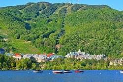
Mont-Tremblant (French pronunciation: [mɔ̃ tʁɑ̃blɑ̃]) is a city in the Laurentian Mountains of Quebec, Canada, approximately 130 kilometres (81 mi) northwest of Montreal and 140 kilometres (87 mi) northeast of Ottawa, Ontario. The current municipality with city status was formed in 2000. Mont-Tremblant is most famous for its ski resort, the Mont-Tremblant Ski Resort, which is 5 kilometres from the village proper, at the foot of a mountain called Mont Tremblant (derived from local Algonquins who referred to it as the "trembling mountain").
Mont-Tremblant has a race track called Circuit Mont-Tremblant. It has hosted or currently hosts Formula One, Can-Am, Trans-Am, and Champ Car World Series competitions amongst others.
The surrounding area also features hiking, cycling, canoeing, fishing, golfing, ziplines, and a host of other outdoor activities.
Since the summer of 2006, Mont-Tremblant has its own senior amateur Canadian football team, the Mystral, and Junior AA hockey team, Les Diables (Devils).
History

The area was inhabited by Algonquins before European colonization. It was settled in 1872 by parish priest Antoine Labelle, leading to formal establishment of the parish in 1879. A railway line from Montreal was completed to the village of Saint-Jovite in 1892, and extended to Lac Mercier in 1904. The Lac-Mercier station would become the village of Mont-Tremblant. In 1905 a hydroelectric dam was erected on the banks of the Ruisseau Clair (Clear River) and the Rivière-du-Diable (Devil's River) providing electricity initially for Saint-Jovite. Principal economic activities were agriculture and logging.
Constructed by Joseph Bondurant Ryan, the ski resort Mont-Tremblant Lodge began operation of their first chair lift in 1939. His family sold the resort in 1965 to a consortium of investors.
In 2002 the four municipalities in the area merged, Ville Saint-Jovite, Paroisse de Saint-Jovite, Mont-Tremblant, and Lac-Tremblant-Nord, becoming the amalgamated Ville de Mont-Tremblant. Afterwards the Municipality of Lac-Tremblant-Nord separated, effective 2006.[4]
Demographics
Population:[5]
- Population in 2006: 8892
- Population in 2001: 8317 (adjusted for boundary change)
- Population total in 1996:
- Mont-Tremblant: 977
- Lac-Tremblant-Nord: 4
- Saint-Jovite (ville): 4609
- Saint-Jovite (parish): 1708
- Population in 1991:
- Mont-Tremblant: 707
- Lac-Tremblant-Nord: 0
- Saint-Jovite (ville): 4118
- Saint-Jovite (parish): 1275
Language:
- English as first language: 7.4%
- French as first language: 89.0%
- Other as first language: 2.3%
Education
.jpg)
The city has five elementary schools on its territory, one high school, one professional training school, and one public college.
The Commission scolaire des Laurentides operates French-language schools:
- Elementary schools: Fleur-Soleil, La-Doyenne, La Ribambelle, Tournesol, Trois Saisons.
- High school: École Polyvalente Curé-Mercure.
The Sir Wilfrid Laurier School Board operates English-language schools:
- Saint Agathe Academy in Sainte-Agathe-des-Monts serves students for both elementary and secondary levels.[6]
- Arundel Elementary School in Arundel also serves students at the elementary level[7]
Professional training school: Centre Le Florès.
CEGEP: Centre Collégial de Mont-Tremblant[8] (also called CEGEP de Saint-Jerome Mont-Tremblant campus).
See also
References
- ↑ Reference number 360952 of the Commission de toponymie du Québec (in French)
- 1 2 "Mont-Tremblant - Répertoire des municipalités - Ministère des Affaires municipales et de l'Occupation du territoire". gouv.qc.ca.
- 1 2 "(Code 2478102) Census Profile". 2011 census. Statistics Canada. 2012.
- ↑ "Ville de Mont-Tremblant, Québec, Canada - Site officiel de la ville de Mont-Tremblant". villedemont-tremblant.qc.ca. Retrieved June 13, 2018.
- ↑ Statistics Canada: 1996, 2001, 2006 census
- ↑ "About Us." Saint Agathe Academy. Retrieved on June 13, 2018. See Elementary zone map and Secondary zone map - Note that all areas covered in the elementary map are also covered in the secondary one.
- ↑ "Arundel Elementary Zone." Sir Wilfrid Laurier School Board. Retrieved on June 13, 2018.
- ↑ "Cégep de Saint-Jérôme -". Cégep de Saint-Jérôme. Retrieved June 13, 2018.
External links
| Wikimedia Commons has media related to Mont-Tremblant. |

- Ville de Mont-Tremblant
- Official Site
- [https://web.archive.org/web/20120116225445/http://tremblantexpress.com/accueilen.php Mont-Tremblant Local Newspaper - Tremblant Express
Places adjacent to Mont-Tremblant | ||||||||||
|---|---|---|---|---|---|---|---|---|---|---|
| ||||||||||
| Cities/towns | |
|---|---|
| Municipalities | |
| Townships | |
| Parishes | |
| Villages | |
| |
| |
| Quebec City area: | |
| Montreal local area: |
|
| Montreal-area Laurentians: |
|
| Eastern Townships: | |
| Gatineau area |
|
| Lanaudière area: |
|
| Saguenay–Lac-Saint-Jean |
|
| |