Mont Brulé
| Mont Brulé | |
|---|---|
| Mont Braoulé | |
 The west side | |
| Highest point | |
| Elevation | 3,585 m (11,762 ft) |
| Prominence | 372 m (1,220 ft) [1] |
| Isolation | 2.33 kilometres (1.45 mi) |
| Coordinates | 45°57′18.8″N 7°32′18.1″E / 45.955222°N 7.538361°ECoordinates: 45°57′18.8″N 7°32′18.1″E / 45.955222°N 7.538361°E |
| Geography | |
 Mont Brulé Location in the Alps | |
| Location | Valais, Switzerland/Aosta Valley, Italy |
| Parent range | Pennine Alps |
| Climbing | |
| First ascent | 7 August 1876 by Arthur Cust and guide. |
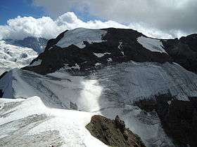
Mont Brulé (also known as Mont Brûlé or Mont Braoulé) is a mountain of the Pennine Alps, located on the Swiss-Italian border, east of the Col Collon. On its northern side it overlooks the upper Arolla Glacier.
Toponym
Though in French this name means "burnt mountain", this toponym comes from Valdôtain Francoprovençal patois. According to Aostan botanist and scientist Joseph-Marie Henry,[2] the word Broillà means "made of breuils", Breuil meaning alpine marshy berm, as for Breuil in Valtournenche.
References
- ↑ Swisstopo map
- ↑ Eau, acqua, éve - entre littérature, science et histoire, éd. Duc, Saint-Christophe, p. 96.
External links
This article is issued from
Wikipedia.
The text is licensed under Creative Commons - Attribution - Sharealike.
Additional terms may apply for the media files.