Mons Argaeus
| Mons Argaeus | |
|---|---|
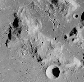 Apollo 17 image | |
| Highest point | |
| Elevation | 7060 m (summit) |
| Listing | Lunar mountains |
| Coordinates | 19°20′N 29°01′E / 19.33°N 29.01°E |
| Geography | |
| Location | the Moon |
Mons Argaeus is near center
Mons Argaeus is a mountainous massif on the Moon that extends for a length of 65 km towards the southeast. It is located at coordinates 19°20′N 29°01′E / 19.33°N 29.01°E,[1] wedging between Mare Serenitatis and Mare Tranquillitatis on their eastern border.[2] The summit is approximately 2560 m above the plain of Mare Serenitatis to the west.
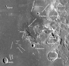
Apollo 17 landed to the east of Mons Argaeus in the Taurus–Littrow Valley (next to Mons Vitruvius and to the south of the crater Littrow).
This rise was given the Latin name for Mount Argaeus, a peak in Turkey now called Erciyes Dağı. The name for this lunar feature was officially adopted by the IAU in 1935.[1]
References
- 1 2 "Mons Argaeus". Gazetteer of Planetary Nomenclature. International Astronomical Union (IAU) Working Group for Planetary System Nomenclature (WGPSN). 2010-10-18. Retrieved 2015-02-14.
- ↑ Grego, Peter (2004). Moon Observer's Guide. Firefly Books. ISBN 1552978885.
External links
- Staff (2007). "42C3S3(50): Mons Argaeus". Lunar and Planetary Institute. Retrieved 2007-07-30.
- LTO-42C3 Dawes — L&PI topographic map
- Staff (2007). "Photo Number IV-078-H3". Digital Lunar Orbiter Photographic Atlas of the Moon. Lunar and Planetary Institute. Retrieved 2007-07-30.
This article is issued from
Wikipedia.
The text is licensed under Creative Commons - Attribution - Sharealike.
Additional terms may apply for the media files.