Monnai
- for the suburb of Rauma, Finland see Monnai, Rauma
| Monnai | |
|---|---|
 Monnai Location within Normandy region  Monnai | |
| Coordinates: 48°53′34″N 0°23′54″E / 48.8928°N 0.3983°ECoordinates: 48°53′34″N 0°23′54″E / 48.8928°N 0.3983°E | |
| Country | France |
| Region | Normandy |
| Department | Orne |
| Arrondissement | Argentan |
| Canton | Rai |
| Intercommunality | Communauté de communes du Canton de la Ferté-Frênel |
| Government | |
| • Mayor (2008–2014) | Daniel Deuley |
| Area1 | 15.52 km2 (5.99 sq mi) |
| Population (2006)2 | 221 |
| • Density | 14/km2 (37/sq mi) |
| Time zone | UTC+1 (CET) |
| • Summer (DST) | UTC+2 (CEST) |
| INSEE/Postal code | 61282 /61470 |
| Elevation |
191–262 m (627–860 ft) (avg. 242 m or 794 ft) |
|
1 French Land Register data, which excludes lakes, ponds, glaciers > 1 km2 (0.386 sq mi or 247 acres) and river estuaries. 2 Population without double counting: residents of multiple communes (e.g., students and military personnel) only counted once. | |
Monnai is a former commune in the Orne department in north-western France. On 1 January 2016, it was merged into the new commune of La Ferté-en-Ouche.[1] It had a population of 222 as of 2004.
History
The village was founded as "Moenai" in 1100. Following the tradition, the chapel Notre-Dame-du-Vallet was built after the discovery of a statue; it was rebuilt in 16th century and again in 1862. The old village of Ternant, mentioned for the first time in 1100, was linked to Monnai.
In 2005, the "Carrefour des Cultures" 5-day international gathering occurred in Monnai.
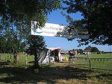
Entrance to the Carrefour des Cultures in Monnai. Banner reads: Hospitality throughout the world
See also
References
- ↑ Arrêté préfectoral 26 October 2015 (in French)
External links
| Wikimedia Commons has media related to Monnai. |
This article is issued from
Wikipedia.
The text is licensed under Creative Commons - Attribution - Sharealike.
Additional terms may apply for the media files.