Momarka
| Momarka | |
|---|---|
| Village | |
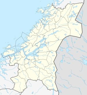
 Momarka Location of the village  Momarka Momarka (Norway) | |
| Coordinates: 63°43′39″N 11°17′03″E / 63.7276°N 11.2841°ECoordinates: 63°43′39″N 11°17′03″E / 63.7276°N 11.2841°E | |
| Country | Norway |
| Region | Central Norway |
| County | Trøndelag |
| District | Innherred |
| Municipality | Levanger |
| Elevation[1] | 56 m (184 ft) |
| Time zone | UTC+01:00 (CET) |
| • Summer (DST) | UTC+02:00 (CEST) |
| Post Code | 7600 Levanger |
Momarka is a village in the municipality of Levanger in Trøndelag county, Norway. It is located just south of the town of Levanger. The Nordlandsbanen railway line and the European route E6 highway both run through the village. Since 2002, Momarka has been considered a part of the town of Levanger urban area so separate population statistics are no longer tracked.[2][3]
References
- ↑ "Momarka, Levanger (Trøndelag)". yr.no. Retrieved 2018-04-02.
- ↑ Statistics Norway (1 January 2002). "Omitted settlements". Archived from the original on 2 April 2007.
- ↑ Rosvold, Knut A., ed. (2018-03-26). "Momarka". Store norske leksikon (in Norwegian). Kunnskapsforlaget. Retrieved 2018-04-02.
This article is issued from
Wikipedia.
The text is licensed under Creative Commons - Attribution - Sharealike.
Additional terms may apply for the media files.