Mollie Kathleen Gold Mine
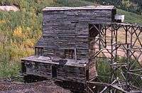
The Mollie Kathleen Gold Mine is a historic vertical shaft mine near Cripple Creek, Colorado.[1] The mine shaft descends 1,000 feet (300 m) into the mountain, a depth roughly equal to the height of the Empire State Building in New York City.[2] The mine currently gives tours, and is visited by around 40,000 people annually.[3] The addition of the mines and subsequent tours of this mine and others in the area had considerable effect on the economies of both Victor, Colorado and Cripple Creek.[4][5][6]
History
The mine was started in 1891 on a mining claim staked by Mollie Kathleen Gortner, after whom the mine was named.[7][8]
Other than a government-ordered hiatus during World War II, the mine operated continuously until 1961; since then it has continued as a tourist attraction.[9]
See also
References
- ↑ Acord, Deb (August 13, 2006). "Mining with monster trucks Tours of Victor mine give passengers golden ticket to region's rich history". The Gazette. Colorado Springs, Colorado.
- ↑ "Go deep in the Molly Kathleen Mine". The Gazette. Colorado Springs, Colorado. August 13, 2006.
- ↑ "Man's fund-raising idea is a gold mine Leasure may reside for a year in shaft beneath Cripple Creek". The Gazette. Colorado Springs, Colorado. June 27, 1992.
- ↑ "City of Victor". The Gazette. Colorado Springs, Colorado. October 17, 1999.
- ↑ "Cripple Creek sees gold in mining town's history". The Gazette. Colorado Springs, Colorado. July 22, 1998.
- ↑ "Colorado Driving Tours: Scenic Golden Loop Historic Parkway: Cripple Creek and Victor, Colorado". Archived from the original on January 24, 2010. Retrieved November 14, 2009.
- ↑ MacKell, Jan (2003). Cripple Creek District: Last of Colorado's Gold Booms. Arcadia Publishing. p. 134. ISBN 0-7385-2413-1. Retrieved November 14, 2009.
- ↑ Casewit, Curtis; Lindberg, Eric (2007). Colorado Off the Beaten Path (9th ed.). Guilford, Connecticut: Globe Pequot. pp. 129–130. ISBN 978-0-7627-4412-1. Retrieved November 14, 2009.
- ↑ Hall, Loretta. Underground Buildings: More Than Meets the Eye. Sanger, California: Quill Driver Books. p. 189. ISBN 1-884956-27-0. Retrieved November 14, 2009.
External links
Coordinates: 38°45′11″N 105°09′38″W / 38.75306°N 105.16056°W