Mola de Colldejou
| Mola de Colldejou | |
|---|---|
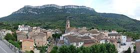 North face of Mola de Colldejou rising above La Torre de Fontaubella | |
| Highest point | |
| Elevation | 921.8 m (3,024 ft) |
| Coordinates | 41°6′32.08″N 0°52′26.43″E / 41.1089111°N 0.8740083°ECoordinates: 41°6′32.08″N 0°52′26.43″E / 41.1089111°N 0.8740083°E |
| Geography | |
 Mola de Colldejou Catalonia, Spain | |
| Location | Baix Camp & Priorat, (Catalonia) |
| Parent range | Catalan Pre-Coastal Range |
| Geology | |
| Mountain type | Karstic |
| Climbing | |
| First ascent | Unknown |
| Easiest route | From Colldejou or La Torre de Fontaubella |
Mola de Colldejou is a mountain chain in Catalonia, Spain located north of the Serra de Llaberia in the Catalan Pre-Coastal Range. The highest point is 921.8 m above sea level.[1]
This mountain range is named after Colldejou village, located east of the range.
See also
References
External links
| Wikimedia Commons has media related to Mola de Colldejou. |
This article is issued from
Wikipedia.
The text is licensed under Creative Commons - Attribution - Sharealike.
Additional terms may apply for the media files.