Mojiguaçu River
| Mojiguaçu River | |
|---|---|
 | |
| Country | Brazil |
| Physical characteristics | |
| Main source | São Paulo state |
| River mouth |
Rio Pardo 20°53′16″S 48°10′39″W / 20.88778°S 48.17750°WCoordinates: 20°53′16″S 48°10′39″W / 20.88778°S 48.17750°W[1] |
| Length | 473 km (294 mi) |
| Basin features | |
| Basin size | 14,463 km2 (5,584 sq mi) |
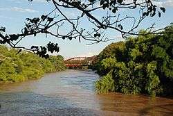
The Mojiguaçu River (Portuguese, Rio Mojiguaçu[2]) or Moji Guaçu River is a river of São Paulo state in southeastern Brazil. It is a tributary of the Rio Pardo, which is a tributary of the Rio Grande.
In the municipality of Porto Ferreira the river forms the southern boundary of the Porto Ferreira State Park, created in 1987.[3]
Notes
- ↑ GNS coordinates adjusted using Google Maps and GeoLocator
- ↑ Rio Mojiguaçu at GEOnet Names Server
- ↑ Parque Estadual Porto Ferreira completa 50 anos (in Portuguese), Fundação Florestal, 21 November 2012, retrieved 2017-01-22
References
- "Mapa Rodoviário São Paulo (Roadmap of São Paulo)" (PDF). Brazilian Ministry of Transport. 2002.
- Rand McNally, The New International Atlas, 1993.
This article is issued from
Wikipedia.
The text is licensed under Creative Commons - Attribution - Sharealike.
Additional terms may apply for the media files.