Moires
| Moires Μοίρες | |
|---|---|
 The centre of Moires | |
 Moires Location within the regional unit 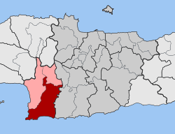 | |
| Coordinates: 35°03′N 24°52′E / 35.050°N 24.867°ECoordinates: 35°03′N 24°52′E / 35.050°N 24.867°E | |
| Country | Greece |
| Administrative region | Crete |
| Regional unit | Heraklion |
| Municipality | Faistos |
| • Municipal unit | 181.9 km2 (70.2 sq mi) |
| Elevation | 90 m (300 ft) |
| Population (2011)[1] | |
| • Municipal unit | 11,434 |
| • Municipal unit density | 63/km2 (160/sq mi) |
| Community[1] | |
| • Population | 6,496 (2011) |
| Time zone | UTC+2 (EET) |
| • Summer (DST) | UTC+3 (EEST) |
Moires (Greek: Μοίρες, "Fates") is a town and a former municipality in the Heraklion regional unit, Crete, Greece. Since the 2011 local government reform it is part of the municipality Faistos, of which it is a municipal unit.[2] Population 11,434 (2011). The municipal unit has an area of 181.885 km2 (70.226 sq mi).[3] The weekly market of the agricultural town of Moires is the largest in the region. In the early Middle Ages it was the home of Christian hermits, who allegedly met only once a year to worship at the chapel of Agios Andonis, built in the 14th or 15th century.
Subdivisions
The municipal unit of Moires is divided into the following communities:
- Moires
- Alithini
- Antiskari
- Galia
- Kastelli
- Kouses
- Peri
- Petrokefali
- Pigaidakia (including Kaloi Limenes)
- Pompia
- Roufas
- Skourvoula
References
- 1 2 "Απογραφή Πληθυσμού - Κατοικιών 2011. ΜΟΝΙΜΟΣ Πληθυσμός" (in Greek). Hellenic Statistical Authority.
- ↑ Kallikratis law Greece Ministry of Interior (in Greek)
- ↑ "Population & housing census 2001 (incl. area and average elevation)" (PDF) (in Greek). National Statistical Service of Greece.
This article is issued from
Wikipedia.
The text is licensed under Creative Commons - Attribution - Sharealike.
Additional terms may apply for the media files.