Morąg
| Morąg | |||
|---|---|---|---|
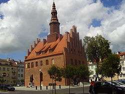 Town hall and marketplace | |||
| |||
 Morąg | |||
| Coordinates: 53°55′N 19°56′E / 53.917°N 19.933°E | |||
| Country |
| ||
| Voivodeship | Warmian-Masurian | ||
| County | Ostróda | ||
| Gmina | Morąg | ||
| Established | 13th century | ||
| Town rights | 1327 | ||
| Government | |||
| • Mayor | Tadeusz Zbigniew Sobierajski | ||
| Area | |||
| • Total | 12.17 km2 (4.70 sq mi) | ||
| Population (2006) | |||
| • Total | 14,497 | ||
| • Density | 1,200/km2 (3,100/sq mi) | ||
| Time zone | UTC+1 (CET) | ||
| • Summer (DST) | UTC+2 (CEST) | ||
| Postal code | 14-300, 14-331 | ||
| Area code(s) | +48 89 | ||
| Car plates | NOS | ||
| Website | http://www.morag.pl | ||
Morąg ([ˈmɔrɔŋk]; German: Mohrungen (![]()
Geography
The town is situated in the western uplands of the historic Prussia region. Its centre is located about 60 km (37 mi) south of the Polish - Russian (Kaliningrad) border. The nearest city is Olsztyn in Warmia, 38 km (24 mi) to the southeast.
History
In medieval times, an Old Prussian settlement existed at the site under the name of Mawrin, Maurin or Morin.[1] A new town was built on its place by the invading Teutonic Knights after they destroyed the original settlement in the late 13th century. Part of the Order's State, it was given the name Mohrungen after a nearby lake and in 1327 attained Kulm town law from the local commander (Komtur) Hermann von Oettingen. The first inhabitants of the town were emigrants from the southern Harz region in central Germany.
After the 1410 Battle of Grunwald the town was occupied by the united forces of the Grand Duchy of Lithuania and the Kingdom of Poland until 1461. During the Polish–Teutonic Hunger War of 1414, Mohrungen incinerated completely. In 1440, the citizens joined the Prussian Confederation and fought against the Tetonic Order in the Thirteen Years' War from 1454 to 1466. Reconquered by the Elbing commander Heinrich Reuß von Plauen in 1461, the town became his seat as deputy Grand Master.
Mohrungen was on a shipping commerce line connecting Truso with harbors at the Black Sea. Agriculture and commerce was the primary occupations in the town. It was known as a cattle and grain market.[2]
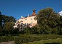
Again conquered by Poland during the Prussian War of 1519–21, Mohrungen upon the Protestant Reformation and the secularisation of the Order's State in 1525 was part of Ducal Prussia, then a Polish fief. The estates were held by Colonel Peter von Dohna (1483–1553), Lord of Schlobitten, whose son Achatius von Dohna (1533–1619) had a castle erected. Peter's grandson Christopher von Dohna (1583–1637) became known as a scholar and governor of the Principality of Orange during the Thirty Years' War. Rebuilt in a Baroque style in the early 18th century, Dohna Castle is today used as a museum.
Mohrungen was again devastated during the Polish–Swedish War in 1626. From 1701 it was part of the Kingdom of Prussia under King Frederick I. It remained the seat of the local administration, since 1752 of Landkreis Mohrungen (Mohrungen province). During the Napoleonic War of the Fourth Coalition, in 1807, Marshal Jean-Baptiste Jules Bernadotte took his residence at Dohna Castle; his French forces were defeated in a skirmish with Russian troops on January 25. An earthquake struck the town in 1818.
The town received access to the Prussian state railways network in 1882. Part of the East Prussian Königsberg region, Mohrungen until 1945 belonged to Germany. It was occupied by Soviet Red Army forces of the 2nd Belorussian Front during the East Prussian Offensive on 23 January 1945. After World War II, the remaining local populace was expelled and the town became part of the re-established Polish Republic according to the Potsdam Agreement, renamed Morąg.
From May 2010 to 2011 the town was the garrison of a US Army Patriot Missile Defense battery.[3]
Sights
After a fire in 1697 only Dohna Castle and the üarish church, which was restored and rebuilt several times, survived. Following World War II in 1945 fires burnt about 45% of the historic town centre. Only the outer walls of the town hall remained.
- The old castle of the Teutonic Knights is being excavated as more of it has been recently discovered.
- The "Dohna-Schlößchen" (Dohna Palace), which was mostly destroyed in the Second World War, was restored in 1986. Now it houses the Museum of Johann Gottfried Herder, an impressive regional museum.
- The main body of the Catholic church of Saint Peter and Saint Paul goes back to the first half of the 14th century.
- The town hall, damaged in the Second World War, was rebuilt from 1947-1954 as it looked before.
- Some ruins of the original town walls still remain.
- Kretowiny (Kranthau), a popular lake and camp ground are only 9 km away and are a favorite and frequent retreat for the local population.
Population
- 1740: 1,067
- 1782: 1,753
- 1820: 2,108
- 1880: 3,742
- 1885: 3,879
- 1890: 3,780
- 1900: 4,025
- 1910: 4,147
- 1925: 4,934
- 1933: 5,414
- 2003: 14,570
- 2010: 13,895
- 2017: 14,042[4]
Famous residents
- Christoph von Dohna (1583–1637), German politician
- Abraham Calovius (1612–1686), Lutheran theologian
- Johann Gottfried von Herder (1744–1803), German author, Lutheran theologian, and eminent enlightenment philosopher
- Friedrich von Zander (1791–1868) Prussian Chancellor
- Gustav Hermann Schmischke (1883-unknown), Gauleiter
- Elisabeth von Thadden (1890–1944), German educator
- Reinold von Thadden-Trieglaff (1891–1976), German theologian
- Alfred Jaedtke (1913–1992), Wehrmacht officer
- Gerhard Bondzin (born 1930), German painter - Gallery
- Bernd Heine (born 1939), German linguist
- Zbigniew Nienacki (1929–1994), Polish writer
- Cezary Worek (1965- ), researcher at the AGH University of Science and Technology in Kraków
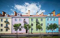 Morąg Old Town
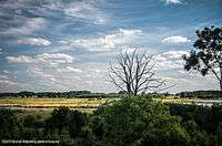 Morąg Marsh
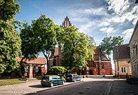 St. Peter and St Paul's church, Morąg
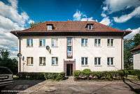 Ogrodowa Street, Morąg
Religion
Pastoral activity in the town is the Roman Catholic Church and the Pentecostal Church - Protestant community on the nature of the Gospel, as well as the Greek Orthodox Church.[5]
See also
References
- ↑ "Archived copy". Archived from the original on 2013-12-30. Retrieved 2013-06-22.
- ↑ Cohen, Saul B., "The Columbia Gazetteer of the World." Columbia University Press, 1998.
- ↑ Poland welcomes US soldiers, Patriot missiles
- ↑ The Population. The status and structure of the territorial section (as of 31 XII 2010). Warsaw: Central Statistical Office, 2011-06-10. ISSN 1734-6118.
- ↑ A. Kopiczko, Panorama, religion of the Olsztyn after World War II, pp. 63, 64
| Wikimedia Commons has media related to Morąg. |
External links
- Municipal website (in Polish)
Coordinates: 53°55′N 19°56′E / 53.917°N 19.933°E