Mogersdorf
| Mogersdorf | ||
|---|---|---|
| ||
 Mogersdorf Location within Austria | ||
| Coordinates: 46°57′N 16°14′E / 46.950°N 16.233°ECoordinates: 46°57′N 16°14′E / 46.950°N 16.233°E | ||
| Country | Austria | |
| State | Burgenland | |
| District | Jennersdorf | |
| Government | ||
| • Mayor | Josef Korpitsch | |
| Area | ||
| • Total | 12.8 km2 (4.9 sq mi) | |
| Elevation | 228 m (748 ft) | |
| Population (1 January 2016)[1] | ||
| • Total | 1,154 | |
| • Density | 90/km2 (230/sq mi) | |
| Time zone | UTC+1 (CET) | |
| • Summer (DST) | UTC+2 (CEST) | |
| Postal code | 8382 | |
| Website | www.mogersdorf.at | |

Mogersdorf (Hungarian: Nagyfalva, Slovene: Modinci[2]) is a town in the district of Jennersdorf in the Austrian state of Burgenland.
History
Mogersdorf has a famous place in Austrian history because it was here that Raimondo Montecuccoli annihilated a 60,000/90,000-strong army of the Ottoman Empire in 1664 upon its attempt to cross the Raab River westwards towards Styria. This Battle of Mogersdorf (also known as the First Battle of St. Gotthard) was commemorated by a chapel on the nearby Schlößlberg hill. Having fallen into disrepair, it was replaced by a new building, with an unadorned but huge Christian cross at its side, in 1964.
Population
| Historical population | ||
|---|---|---|
| Year | Pop. | ±% |
| 1869 | 1,638 | — |
| 1880 | 1,864 | +13.8% |
| 1890 | 2,182 | +17.1% |
| 1900 | 2,265 | +3.8% |
| 1910 | 2,235 | −1.3% |
| 1923 | 2,058 | −7.9% |
| 1934 | 1,930 | −6.2% |
| 1939 | 1,830 | −5.2% |
| 1951 | 1,699 | −7.2% |
| 1961 | 1,577 | −7.2% |
| 1971 | 1,454 | −7.8% |
| 1981 | 1,317 | −9.4% |
| 1991 | 1,264 | −4.0% |
| 2001 | 1,213 | −4.0% |
| 2011 | 1,146 | −5.5% |
| 2017 | 1,187 | +3.6% |
References
- ↑ Statistik Austria - Bevölkerung zu Jahresbeginn 2002-2016 nach Gemeinden (Gebietsstand 2016-01-01) for Mogersdorf.
- ↑ Makuc, Neva (2011). Historiografija in mentaliteta v novoveški Furlaniji in Goriški. Ljubljana: Založba ZRC. p. 276.
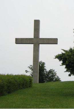
Stonecross of Schösslberg, over Mogersdorf; monument of the Battle of Saint Gotthard (1664).
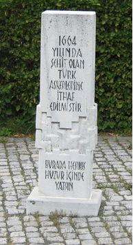
The monument of the casualty Turks in Mogersdorf
This article is issued from
Wikipedia.
The text is licensed under Creative Commons - Attribution - Sharealike.
Additional terms may apply for the media files.