Mogelsberg
| Mogelsberg | |
|---|---|
| Former municipality of Switzerland | |
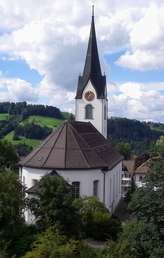 | |
 Mogelsberg | |
|
Location of Mogelsberg 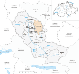 Mogelsberg Mogelsberg (Canton of St. Gallen) | |
| Coordinates: 47°22′N 9°7′E / 47.367°N 9.117°ECoordinates: 47°22′N 9°7′E / 47.367°N 9.117°E | |
| Country | Switzerland |
| Canton | St. Gallen |
| District | Toggenburg |
| Area | |
| • Total | 32.96 km2 (12.73 sq mi) |
| Elevation | 755 m (2,477 ft) |
| Population | |
| • Total | 2,213 |
| • Density | 67/km2 (170/sq mi) |
| Postal code | 9122 |
| SFOS number | 3406 |
| Surrounded by | Brunnadern, Degersheim, Ganterschwil, Hemberg, Lütisburg, Oberhelfenschwil, Sankt Peterzell, Schwellbrunn (AR) |
| Website |
www SFSO statistics |
Mogelsberg is a municipality in the Wahlkreis (constituency) of Toggenburg in the canton of St. Gallen in Switzerland.
Mogelsberg was an independent municipality until January 1, 2009, when it merged with Brunnadern and St. Peterzell to form the municipality of Neckertal.[1]
References
- ↑ Amtliches Gemeindeverzeichnis der Schweiz published by the Swiss Federal Statistical Office (in German) accessed 14 January 2010
External links
- Official website (in German)
- Mogelsberg in German, French and Italian in the online Historical Dictionary of Switzerland.
| Wikimedia Commons has media related to Mogelsberg. |
This article is issued from
Wikipedia.
The text is licensed under Creative Commons - Attribution - Sharealike.
Additional terms may apply for the media files.