Moel Ysgyfarnogod
| Moel Ysgyfarnogod | |
|---|---|
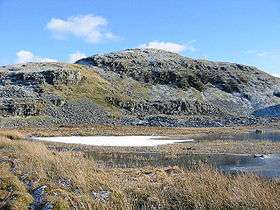 Moel Ysgyfarnogod from Llyn Dywarchen | |
| Highest point | |
| Elevation | 623 m (2,044 ft) |
| Prominence | 180 m (590 ft) |
| Parent peak | Rhinog Fawr |
| Listing | Marilyn, Hewitt, Nuttall |
| Coordinates | 52°53′28.14″N 3°59′46.21″W / 52.8911500°N 3.9961694°WCoordinates: 52°53′28.14″N 3°59′46.21″W / 52.8911500°N 3.9961694°W |
| Naming | |
| Translation | hill of hares (Welsh) |
| Pronunciation | Welsh: [ˈmɔil ˈəsɡəvarˈnɔɡɔd] |
| Geography | |
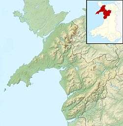 Moel Ysgyfarnogod Location in Gwynedd | |
| Location | Gwynedd, Wales |
| Parent range | Rhinogydd |
| OS grid | SH658345 |
| Topo map | OS Landranger 124 |
| Listed summits of Moel Ysgyfarnogod | ||||
| Name | Grid ref | Height | Status | |
|---|---|---|---|---|
| Foel Penolau | 614 metres (2,014 ft) | sub Hewitt, Nuttall | ||
Moel Ysgyfarnogod (Bare hill of the hares in Welsh) is a mountain in Snowdonia, North Wales and is the northernmost of the Rhinogydd. Rhinog Fawr lies directly south.[1]
It overlooks Llyn Trawsfynydd, and from the summit it is possible to see the towns of Porthmadog and Blaenau Ffestiniog. It may be climbed from Trawsfynydd in the east, or from Talsarnau in the west.
To the north-west of the summit, on an area of moorland and rocky outcrops, lies Bryn Cader Faner, an ancient stone circle. It is one of the finest examples of a Bronze Age cairn in Britain, and has rocky standing stones along its circumference.[2]
References
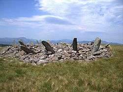
Bryn Cader Faner
- ↑ Nuttall, John & Anne (1999). The Mountains of England & Wales - Volume 1: Wales (2nd edition ed.). Milnthorpe, Cumbria: Cicerone. ISBN 1-85284-304-7.
- ↑ Bryn Cader Faner Ring Cairn : The Megalithic Portal and Megalith Map:
External links
This article is issued from
Wikipedia.
The text is licensed under Creative Commons - Attribution - Sharealike.
Additional terms may apply for the media files.