Mocane, Oklahoma
| Mocane | |
|---|---|
| Unincorporated community | |
 Mocane Location within the state of Oklahoma  Mocane Mocane (the US) | |
| Coordinates: 36°53′37″N 100°22′22″W / 36.89361°N 100.37278°WCoordinates: 36°53′37″N 100°22′22″W / 36.89361°N 100.37278°W | |
| Country | United States |
| State | Oklahoma |
| County | Beaver |
| Elevation | 2,631 ft (802 m) |
| Time zone | UTC-6 (Central (CST)) |
| • Summer (DST) | UTC-5 (CDT) |
| GNIS feature ID | 1100640 |
Mocane is an unincorporated community in Beaver County, Oklahoma, United States. Its elevation is 2,631 feet (802 m).[1] A post office once operated in Mocane, but it is no longer in existence.[2] Mocane is the closest community to the Billy Rose Archeological Site, which is listed on the National Register of Historic Places.[3]
References
Municipalities and communities of Beaver County, Oklahoma, United States | ||
|---|---|---|
| Towns | 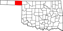 | |
| CDP | ||
| Other unincorporated communities | ||
This article is issued from
Wikipedia.
The text is licensed under Creative Commons - Attribution - Sharealike.
Additional terms may apply for the media files.