Subsidence

Subsidence is either the sudden sinking or gradual downward settling of the ground's surface with little or no horizontal motion. The definition of subsidence is not restricted by either rate, magnitude, or area involved in the downward movement. Subsidence may be caused by either natural processes or human activitites. Natural proceses include various karst phenomena, thawing of permafrost, consolidation, oxidation of organic soils, slow crustal warping (isostatic adjustment), normal faulting, caldera subsidence, or withdrawal of fluid lava from beneath a solid crust. Human activities such as subsurface mining or the extraction of underground fluids, e.g. petroleum, natural gas, or groundwater.[1][2] Ground subsidence is of concern to geologists, geotechnical engineers, surveyors, engineers, urban planners, landowners, and the public in general. Subsidence is a global problem.[3]
Dissolution of limestone
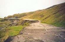
Subsidence frequently causes major problems in karst terrains, where dissolution of limestone by fluid flow in the subsurface causes the creation of voids (i.e., caves). If the roof of these voids becomes too weak, it can collapse and the overlying rock and earth will fall into the space, causing subsidence at the surface. This type of subsidence can result in sinkholes which can be many hundreds of meters deep.
Mining
Several types of sub-surface mining, and specifically methods which intentionally cause the extracted void to collapse (such as pillar extraction, longwall mining and any metalliferous mining method which uses "caving" such as "block caving" or "sub-level caving") will result in surface subsidence. Mining-induced subsidence is relatively predictable in its magnitude, manifestation and extent, except where a sudden pillar or near-surface underground tunnel collapse occurs (usually very old workings[4]). Mining-induced subsidence is nearly always very localized to the surface above the mined area, plus a margin around the outside.[5] The vertical magnitude of the subsidence itself typically does not cause problems, except in the case of drainage (including natural drainage)–rather, it is the associated surface compressive and tensile strains, curvature, tilts and horizontal displacement that are the cause of the worst damage to the natural environment, buildings and infrastructure.[6]
Where mining activity is planned, mining-induced subsidence can be successfully managed if there is co-operation from all of the stakeholders. This is accomplished through a combination of careful mine planning, the taking of preventive measures, and the carrying out of repairs post-mining.

Extraction of natural gas
If natural gas is extracted from a natural gas field the initial pressure (up to 60 MPa (600 bar)) in the field will drop over the years. The gas molecules help support the soil layers above the field. If the gas is extracted, the overburden pressure sediment compacts and may lead to subsidence at the ground level.
Since exploitation of the Slochteren (Netherlands) gas field started in the late 1960s the ground level over a 250 km² area has dropped by a current maximum of 30 cm.[7]
Earthquake
Land subsidence can occur in various ways during an earthquake. Large areas of land can subside drastically during an earthquake because of offset along fault lines. Land subsidence can also occur as a result of settling and compacting of unconsolidated sediment from the shaking of an earthquake.[8]
The Geospatial Information Authority of Japan reported immediate subsidence caused by the 2011 Tōhoku earthquake.[9] In Northern Japan, subsidence of 0.50 m (1.64 ft) was observed on the coast of the Pacific Ocean in Miyako, Tōhoku, while Rikuzentakata, Iwate measured 0.84 m (2.75 ft). In the south at Sōma, Fukushima, 0.29 m (0.95 ft) was observed. The maximum amount of subsidence was 1.2 m (3.93 ft), coupled with horizontal diastrophism of up to 5.3 m (17.3 ft) on the Oshika Peninsula in Miyagi Prefecture.[10]
Groundwater-related subsidence
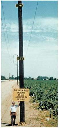
Groundwater-related subsidence is the subsidence (or the sinking) of land resulting from groundwater extraction. It is a growing problem in the developing world as cities increase in population and water use, without adequate pumping regulation and enforcement. One estimate has 80% of serious land subsidence problems associated with the excessive extraction of groundwater,[11] making it a growing problem throughout the world.
Groundwater fluctuations can also indirectly affect the decay of organic material. The habitation of lowlands, such as coastal or delta plains, requires drainage. The resulting aeration of the soil leads to the oxidation of its organic components, such as peat, and this decomposition process may cause significant land subsidence. This applies especially when ground water levels are periodically adapted to subsidence, in order to maintain desired unsaturated zone depths, exposing more and more peat to oxygen. In addition to this, drained soils consolidate as a result of increased effective stress.[12][13] In this way, land subsidence has the potential of becoming self-perpetuating, having rates up to 5 cm/yr. Water management used to be tuned primarily to factors such as crop optimization but, to varying extents, avoiding subsidence has come to be taken into account as well.
Faulting induced
When differential stresses exist in the Earth, these can be accommodated either by geological faulting in the brittle crust, or by ductile flow in the hotter and more fluid mantle. Where faults occur, absolute subsidence may occur in the hanging wall of normal faults. In reverse, or thrust, faults, relative subsidence may be measured in the footwall.
Isostatic subsidence
The crust floats buoyantly in the asthenosphere, with a ratio of mass below the "surface" in proportion to its own density and the density of the asthenosphere. If mass is added to a local area of the crust (e.g., through deposition), the crust subsides to compensate and maintain isostatic balance.
The opposite of isostatic subsidence is known as isostatic rebound—the action of the crust returning (sometimes over periods of thousands of years) to a state of isostacy, such as after the melting of large ice sheets or the drying-up of large lakes after the last ice age. Lake Bonneville is a famous example of isostatic rebound. Due to the weight of the water once held in the lake, the earth's crust subsided nearly 200 feet (61 m) to maintain equilibrium. When the lake dried up, the crust rebounded. Today at Lake Bonneville, the center of the former lake is about 200 feet (61 m) higher than the former lake edges.
Seasonal effects
Many soils contain significant proportions of clay. Because of the very small particle size, they are affected by changes in soil moisture content. Seasonal drying of the soil results in a lowering of both the volume and the surface of the soil. If building foundations are above the level reached by seasonal drying, they move, possibly resulting in damage to the building in the form of tapering cracks.
Trees and other vegetation can have a significant local effect on seasonal drying of soils. Over a number of years, a cumulative drying occurs as the tree grows. That can lead to the opposite of subsidence, known as heave or swelling of the soil, when the tree declines or is felled. As the cumulative moisture deficit is reversed, which can last up to 25 years, the surface level around the tree will rise and expand laterally. That often damages buildings unless the foundations have been strengthened or designed to cope with the effect.
See also
- Cave-in
- Lateral and subjacent support, a related concept in property law
- UNESCO Working Group on Land Subsidence
References
| Wikimedia Commons has media related to Subsidence. |
| Look up subsidence in Wiktionary, the free dictionary. |
- ↑ Neuendorf, K.K.E., J.P. Mehl, Jr., and J.A. Jackson, eds. (205) Glossary of Geology (5th ed.). Alexandria, Virginia, American Geological Institute. 779 p. ISBN 0-922152-76-4
- ↑ Galloway, D.L., Jones, D.R. and Ingebritsen, S.E., 1999. Land subsidence in the United States. Circular 1182. US Department of the Interior, US Geological Survey, Reston, Virgina. 177 p.
- ↑ National Research Council, 1991. Mitigating losses from land subsidence in the United States. National Academies Press. 58 p.
- ↑ Herrera, G.; Tomás, R.; López-Sánchez, J.M.; Delgado, J.; Mallorquí, J.; Duque, S.; Mulas, J. Advanced DInSAR analysis on mining areas: La Union case study (Murcia, SE Spain). Engineering Geology, 90, 148-159, 2007.
- ↑ "Graduated Guidelines for Residential Construction (New South Wales) Volume 1" (PDF). Retrieved 2012-11-19.
- ↑ G. Herrera, M.I. Álvarez Fernández, R. Tomás, C. González-Nicieza, J. M. Lopez-Sanchez, A.E. Álvarez Vigil. Forensic analysis of buildings affected by mining subsidence based on Differential Interferometry (Part III). Engineering Failure Analysis 24, 67-76, 2012.
- ↑ Subsidence lecture Archived 2004-10-30 at the Wayback Machine.
- ↑ "Earthquake Induced Land Subsidence". Retrieved 2018-06-25.
- ↑ 平成23年(2011年)東北地方太平洋沖地震に伴う地盤沈下調査 [Land subsidence caused by 2011 Tōhoku earthquake and tsunami] (in Japanese). Geospatial Information Authority of Japan. 2011-04-14. Retrieved 2011-04-17.
- ↑ Report date on 19 March 2011, Diastrophism in Oshika Peninsula on 2011 Tōhoku earthquake and tsunami, Diastrophism in vertical 2011-03-11 M9.0, Diastrophism in horizontal 2011-03-11 M9.0 Geospatial Information Authority of Japan
- ↑ USGS Fact Sheet-165-00 December 2000
- ↑ Tomás, R.; Márquez, Y.; Lopez-Sanchez, J.M.; Delgado, J.; Blanco, P.; Mallorquí, J.J.; Martínez, M.; Herrera, M.; Mulas, J. Mapping ground subsidence induced by aquifer overexploitation using advanced Differential SAR interferometry: Vega Media of the Segura river (SE Spain) case study. Remote Sensing of Environment, 98, 269-283, 2005
- ↑ R. Tomás, G. Herrera, J.M. Lopez-Sanchez, F. Vicente, A. Cuenca, J.J. Mallorquí. Study of the land subsidence in the Orihuela city (SE Spain) using PSI data: distribution, evolution and correlation with conditioning and triggering factors. Engineering Geology, 115, 105-121, 2010.
Geologic principles and processes | ||
|---|---|---|
| Stratigraphic principles |  | |
| Petrologic principles | ||
| Geomorphologic processes | ||
| Sediment transport | ||