Minamikyūshū
| Minamikyūshū 南九州市 | |||
|---|---|---|---|
| City | |||
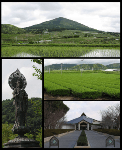 From top:Mount Ōno, statue of Buddha at Shimizu-iwaya Park, tea plantation, Chiran-Tokkō Heiwa Hall | |||
| |||
|
Location of Minamikyūshū in Kagoshima Prefecture | |||
 Minamikyūshū Location in Japan | |||
| Coordinates: 31°22′40″N 130°26′31″E / 31.37778°N 130.44194°ECoordinates: 31°22′40″N 130°26′31″E / 31.37778°N 130.44194°E | |||
| Country | Japan | ||
| Region | Kyushu | ||
| Prefecture | Kagoshima Prefecture | ||
| Government | |||
| • Mayor | Hiroyuki Nuruki | ||
| Area | |||
| • Total | 357.85 km2 (138.17 sq mi) | ||
| Population (March 31, 2011) | |||
| • Total | 39,738 | ||
| • Density | 110/km2 (290/sq mi) | ||
| Symbols | |||
| • Tree | Cherry blossom, Tea | ||
| • Flower | sunflower | ||
| Time zone | UTC+9 (JST) | ||
| City hall address |
6204 Chiran-cho kōri, Minamikyushu-shi, Kagoshima-ken 897-0392 | ||
| Website | www.city.minamikyushu.lg.jp | ||
Minamikyūshū (南九州市 Minamikyūshū-shi, lit. "South Kyushu City") is a city located on the southern tip of Satsuma Peninsula, in Kagoshima Prefecture, Japan.
As of March 31, 2011, the city has an estimated population of 39,738, with 17,288 households and a population density of 111.05 per km². The total area is 357.85 km².
The modern city of Minamikyūshū was established on December 1, 2007, from the merger of the town of Ei (from Ibusuki District), and the towns of Chiran and Kawanabe (both from Kawanabe District).
External links

- Minamikyūshū City official website (in Japanese)
| Core city | |||||||||||
|---|---|---|---|---|---|---|---|---|---|---|---|
| Cities |
| ||||||||||
| Districts |
| ||||||||||
This article is issued from
Wikipedia.
The text is licensed under Creative Commons - Attribution - Sharealike.
Additional terms may apply for the media files.